Exploring Mongolia: A Keck Geology Consortium Research Project in the Gobi
http://keck.carleton.edu
July-August 2003
[Geology of Field Area] [Schedule] [Student Projects] [Culture]
Faculty
Bayanmonh (Bayanna) - Mongolian University of Science and Technology (MUST)
A. Bayasgalan (Bayassa) - Mongolian University of Science and Technology
Bob Carson (director) - Whitman College
Cari Johnson - University of Utah
Kevin Pogue - Whitman College (Kevin's Mongolia site)
Karl Wegmann - Washington Division of Geology and Earth Resources
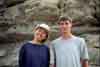
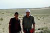
Students
Peter Anderson - Colorado College
Megan Berney-Roberts - Whitman College
Sarah Davidson - Beloit College
Justin Gosses - Franklin & Marshall College
Joseph Graly - Carleton College
Phillip Kast - Pomona College
Kate Krug - Beloit College
Kate Ritley - Whitman College
Jonah Stinson - Whitman College
Battsetseg - Mongolian University of Science and Technology
Ts. Gansuh - Mongolian University of Science and Technology
B. Hashgerel - Mongolian University of Science and Technology
N. Manchuk - Mongolian University of Science and Technology
E. Molor - Mongolian University of Science and Technology
M. Ochirbat - Mongolian University of Science and Technology
E. Odontuya - Mongolian University of Science and Technology
N. Purevdorj - Mongolian University of Science and Technology
Kh. Tsetsegmaa - Mongolian University of Science and Technology
B. Tuya - Mongolian University of Science and Technology
Staff
Bokhoo, driver
Ben Carson, field assistant, musician (University of California, Santa Cruz)
Chris Carson, field assistant, biologist
Chimgee, cook
Dagva, driver
Dami, driver
Hulan, cook
Sengee, driver
Toroo, driver
Tsogto, field assistant (Mongolian University of Science and Technology)
John Wegmann, physician, field assistant
Visiting Faculty
Ch. Minjin, Mongolian University of Science and Technology


Geological Characteristics of Field Area
Mongolia is made of many terranes, which were continental fragments, island arcs, and sea floor. These terranes were caught in a vice as the Siberian craton and North China block came together in the Paleozoic. Our research area included two probable terranes. The northern terrane consists of Upper Proterozoic (?) igneous and metamorphic rocks. The southern terrane includes: Upper Ordovician fossiliferous limestone and clastic sedimentary rocks; Devonian intrusives; Permian volcanics and sandstone; and Jurassic conglomerate (with sandstone) and granite/granodiorite. The two terranes are intruded by Permian diorite/granodiorite/diorite.
Late Jurassic and Early Cretaceous rifting resulted in subsidence and the accumulation of fluvial and lacustrine sediments (host of an oil field near the study area) as well as basaltic and rhyolitic volcanism. The area is overlain by flat lying Upper Cretaceous sandstone and mudstone. Relative stability in the Cenozoic led to the development of extensive pediments. The widespread bedrock and regs (surfaces with desert pavement) are interrupted by scattered dune fields and a meteor impact crater.
Schedule
15-17 July Americans travel from various U.S. destinations to Ulaanbaatar, Mongolia 17-18 July Mongolians and Americans meet; lectures on geology of Mongolia 18-21 July Caravan in six vehicles from Ulaanbaatar to Tavan Har, with stop at Upper Cretaceous strata bearing dinosaur bones 22-23 July Reconnaissance trips in field area to see the variety of rocks and help students select projects 24 July - 6 Aug Fieldwork on projects with exception of day off on 3 August due to gas shortage; students worked on geologic reports starting 3 August 7-12 August Caravan from Tavan Har to Ulaanbaatar with the following stops:
1. "The Amphitheatre": to investigate Jurassic fluvial and lacustrine sediments (with petrified wood).
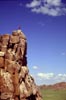
2. Three granitic plutons to see landforms similar to those at Castle Rock and City of Rocks, southern Idaho (sites of two former Keck projects).
3. Two Quaternary faults, one a thrust fault and the other a normal fault.12-14 August End of Mongolian project: packing samples, paperwork, cultural event 14 August Americans return to U.S.A.
Student Projects
Kate D. Krug
"Petrologic And Field Analysis Of The Tavan Har Ovoo Intrusive/Metamorphic Complex, Southeast Gobi Desert, Mongolia"
Medium grade metamorphic rocks of multiple lithologies crop out in the Tavan Har area. The rocks were previously mapped as basement material composed of greenschist, gabbro, and gneiss. Traverses of ten valleys and ridges showed the lithologies to include: greenschist/stone, gabbro, granite, diorite, gneiss, and multiple generations of felsic intrusives. We created a cross-section with NW-SE trending transects through the range. The cross-section expresses the field relationships between units. The second generation of felsic intrusives crosscuts all other units in the field, making it the constraining unit for the Tavan Har suite of crystalline rocks.

Kate D. Krug
Megan Berney-Roberts & Khuut Tsetsegmaa
"Upper Ordovician Rocks of Tavan Har Regions, Southeastern Mongolia"
The Zuun Gashuun and Hoovor Formations, thought to be deposited during the Upper Ordovician, are widespread in the Tavan Har region. The lithologies are mainly argillite, quartzite and marble due to low-grade metamorphism. Many of the marble lenses contain crinoids, corals, gastropods, brachiopods, and bryozoans. In addition to the macrofossils, conodonts and algal mats may be found in the marble units. Conodonts may be used to refine the dates of the supposed Ordovician rocks, and the macrofossils will be used to reconstruct the paleoenvironment.

Megan Berney-Roberts & Khuut Tsetsegmaa
Ts. Gansuh & Battseteg
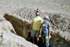
The investigation area is located on the K-49-4A map in the northwestern part of the study area. In this area Middle-Upper Ordovician deposits of Sangiin Dalai formations are distributed. A detailed geological map at a scale of 1:2500 was created. The trenches made during geological mapping were logged. GPS locations of the trenches are:Trench 1 - 43° 57' 49.6" 109° 33' 52", altitude - 865 m asl.Middle-Upper Ordovician sandstone, schist, metasandstone, mudstone and metamudstone have higher grades of As and Zn.
Trench 2 - 43° 57' 49.5" 109° 33' 53.3", altutude - 865 m asl.
N. Purevdorj & B. Tuya
The investigated area is located on the K-49-4dmap in the southeastern part of the study area. In this area Middle-Upper Carboniferous deposits of Ulziit-Uul formations are distributed. Hematite dikes cut through andesite. A 1:2500 scale geological map was made of the surveyed area (0.5 x 0.4 km). Both trenches opened during geological mapping by previous investigators were logged. Trench location by GPS are:Trench 1 - 43° 46' 42.3" 109° 51' 45", altitude - 1153 m asl.Hematite mineralization zones were revealed in both trenches.
Trench 2 - 43° 46' 45.2" 109° 51' 46.5", altitude - 1148 m asl.

Gansuh/Battseteg & Purevdorj/Tuya
Joseph Graly & Molor Erdembat
"An Intrusive Complex in the Khovsgol-Ulaanbadrakhia Terrane, southeastern Mongolia"
The complex consists of several hundred near vertical dikes intruded into a felsic pluton. The dikes studied range in latitude from 43ˇ 48' 30" to 43ˇ 40' 40"N and in longitude from 109ˇ 50' 40" to 110ˇ 07' 10"E. Mafic, felsic, and intermediate compositions are present. The dikes are offset by hundreds of faults with displacements of one to one hundred meters. In many cases, relative age relationships can be established as younger dikes intrude along the fault planes on which older dikes are displaced. The central part of the complex exhibits at least four generations of dikes: 1. felsic, 2. mafic-intermediate, 3. felsic, 4. intermediate. Toward the periphery the oldest dikes are mafic and are crosscut by felsic and intermediate dikes. The complex is cut by two dike swarms of 14 and 19 parallel dikes.

Joseph Graly & Molor Erdembat
Sarah Davidson & Hashgerel Bat-Erdene
"Sedimentology of the Cretaceous intercontinental rift sequence in Tavan Har, southern Mongolia"
Uplift and subsidence related to a Late Jurassic - Early Cretaceous intercontinental rift event led to sediment deposition that includes eolian, lacustrine, and deltaic facies. The Tavan Har area of the Gobi Desert contains sediments from throughout the rift sequence. All units in the area are non-marine, and consist primarily of conglomerates, lacustrine sequences, and volcanic rocks. The earliest synrift deposits are marked by coarse conglomerates with primarily volcanic and metasedimentary lithologies, as well as basalt and ash beds. Later synrift units include lacustrine and additional volcanic deposition. Synrift units are typically slightly folded, and are uncomformably overlain by undeformed postrift sediments. Postrift sediments are generally terrestrial conglomerates and sandstones. Detailed descriptions of these units can help us understand changes in sediment provenance, paleogeography and depositional environments throughout the rifting event.

Sarah Davidson & Haghgenel Bat-Erdene
Justin Gosses & Haghgenel Bat-Erdene
"Sedimentology of the Tsagantsav Formation, Tavan Har, Southeastern Mongolia"
The Tsagantsav formation, one of several Cretaceous rift formations in southeastern Mongolia and northern China, is of lowermost Cretaceous age. It overlaps uncomformably and is faulted against Proterozoic and Paleozoic rocks. The basal unit of the Tsagantsav, a conglomerate containing green chloritic clasts, grades into a non-chloritic conglomerate, which is overlain by lacustrine sediuments; including calcareous and non-calcareous shales, sandstones, and water-laid tuffs. Many of the lacustrine deposits exhibit decimeter scale cycles of calcareous sandstone, calcareous shale, and non-calcareous shale. The shales contain mollusk, gastropod, fish, and plant fossils. These lacustrine deposits, being inter-bedded with basalt and exhibiting rapid facies changes both laterally and stratigraphically, support the interpretation of the Tsagantsav as a syn-rift environment.
Justin Gosses & Haghgenel Bat-Erdene
Phillip Kast & N. Manchuk
"New Evidence for Quaternary Faulting in Southeast Mongolia"
The first known Quaternary fault in southeast Mongolia is located in the Tavan Har area. It is unusually wide, displaying a shear zone with gouge and breccia over 400 m in width. The combination of ductile and brittle shearing observed suggest a long history of movement. The fault may reactivate the boundary between the Ulan Uul and Hovsgol-Ulaanbadrahin terranes, placed in the area by previous mapping. Over 15 km of the fault trace has been mapped: it trends northeast-southwest, then, further northeast, curves to trend east-west. Crosscutting relationships observed in two trenches suggest Quaternary motion. Several lines of evidence suggest left-oblique motion. Air photos may reveal offset streams and large scale features related to terrane suturing.
Phillip Kast & N.Manchuk
Peter Anderson and M. Ochirbat
"The Tavan Hat Impact Crater, Southeastern Gobi, Mongolia"
The impact crater of the northeastern Tavan Har region is located in greenschist facies metamorphic rocks with both felsic and mafic protoliths. The crater has a diameter of 1.75 km and covers an area of 137 hectares. At least two episodes of deformation have affected the country rock, the first deformation event forming a foliation plane that is parallel to subparallel to bedding. The second deformation event folded foliation and produced spaced axial plane fracture cleavages. The two foliations produce an intersection lineation which, when viewed in the structure, shows the beds to be generally striking northeast- southwest and overturned on the northeastern rim of the crater. The lineations on the northwest and southeast rims of the crater dip away from the crater center and are support for the impact origin of the crater. Dikes of various lithologies were intruded after the deformation events and strike parallel to foliation. Scattered outcrops of breccia with calcareous cement are possible dikes related to the impact.
Peter Anderson & M. Ochirbat
Jonah Stinson & Erdenebat Odontuya
"Longitudinal Dunes of the Tavan Har Crater, Southeastern Gobi, Mongolia"
A number of longitudinal dunes up to 2 km long are located along the southeastern rim of the Tavan Har Crater. Here, peaks of the eroded crater rim act like a snow fence to cause deposition of sand downwind of the crater, resulting in a series of dunes running subparallel to one another at N80W. This orientation is the areaŐs prevailing wind direction, which is also indicated by the orientation of grooves in wind-abraded bedrock on the crater rim. Although dominant wind directions are from the west, other winds from the north and south change the steepest slip face from side to side and Ňwag the tailsÓ of the longitudinal dunes. Satellite imagery reveals large areas of unconsolidated sediment to the northwest that is the probable source area for these dunes.

Jonah Stinson & Erdenebat Odontuya
Kate Ritley & Erdenebat Odontuya
"Yardangs and Dome Dunes of Mongolia's Gobi"
Northeast of Tavan Har is a 5 km2 area characterized by yardangs, dome dunes, and other eolian features. The yardangs are eroded from Upper Cretaceous, cross-bedded muddy sands, and nearly all are oriented along a northwest-southeast axis, with a tall, steep northwest side and a gently sloping southeast side. Adjacent dome dunes contain beds dipping in all directions. In this sand sea the dome dunes are transitional to other types of dunes: longitudinal dune characteristics include a long axis in a northwest-southeast direction, and slip faces have characteristics of both transverse and barchan dunes in different places. Other wind-related landforms include: vegetated sand mounds, which appear to be positive-feedback features; vegetation-anchored sand pedestals; and inactive, semi-consolidated dunes currently being eroded. In total the eolian landforms indicate prevailing winds from the northwest and variable winds from all directions.

Kate Ritley & Erdenebat Odontuya
Culture
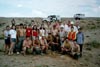
Being in the capital, Ulaanbaatar, for a few days was an introduction to the culture of Mongolia. But this only large city in Mongolia is much different from the tiny towns and scattered gers of the steppe and the Gobi to the south. Four of us from the US learned some Mongolian rather quickly, allowing interaction with the townsfolk and the nomadic herders.
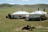
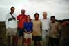
At base camp we had no visitors; the interaction was between the Americans and our Mongolian hosts. Two guitars helped with lots of singing of Mongolian and Western songs. Some of us learned the Mongolian national anthem; some of them learned "Cecilia" (both were sung by all at the final banquet). A volleyball net was set up; we also played with Hacky Sacks and Frisbees, and arm-wrestled. Engaging in sports and music were not only the students but also every else on the expedition, particularly the drivers.

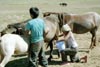
On our travel between Ulaanbaatar and the Gobi we had lots of interaction with other Mongolians. Local people would walk or ride horses to our campsite. We would stop to meet herdsmen and ride their horses and camels. The drivers stopped often for a bowl of a Mongolian specialty, fermented mare's milk. We were invited into gers for this "milk" and other goodies. At gas stations, in camp, and in gers, we sang, often with local inhabitants.