Quaternary geology of the Turgen Uul area, northern Altay, western Mongolia
2004 Keck Geology Consortium Research Project
Faculty
A. Bayasgalan (Bayassa) - Mongolian University of Science and Technology
Bob Carson (director) - Whitman College
Rick Hazlett - Pomona College
Approximate Dates
Mid-July to mid-August, 2004
Physiography
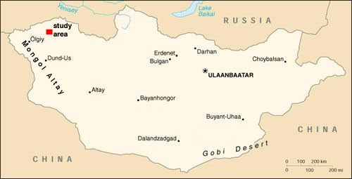
The proposed area of study is bound by latitudes 49°20' and 50° N and longitudes 91° and 92°E in western Mongolia (we will concentrate our efforts in the southern half). This 5000-km2 area lies in Bayan-Olgii aimag less than 100 km south of Russia/Siberia. Just southeast is the arid northwestern end of the Depression of Great Lakes; precipitation increases northwestly to the highest peak in this part of the Altay (Kharkhiraa Uul, 4037 m). The lowlands have many freshwater and saltwater lakes. Glaciers of the high peaks were much more extensive during Pleistocene glaciation. Discontinuous permafrost underlies the area; periglacial features are widespread. August is the wettest month in Mongolia, so a little rain and snow is expected. Daily temperatures will likely be between 0 and 20°C.
Click to load full size (rather large) image in a new window.
Regional Geology
The geology of Mongolia is complex: geological maps reveal the variety and complexity of rock types and structures, with representatives of all geological ages from Precambrian to Tertiary. Geologically, Mongolia is an important link between the Siberian Craton, essentially an amalgamation of Lower Paleozoic terranes, and northern China, an area of complex Middle Paleozoic-Tertiary suturing and tectonics. The rocks record successive episodes of terrane accretions and consequent deformation. These tectonic boundaries encompass 'plates': collections of smaller terranes which formed as continental fragments were successively plastered against, and welded to, the much larger Siberian Craton during the Paleozoic. The timing of these accretions in Mongolia can be constrained by the available stratigraphic, structural, and radiometric data, and it is possible to reconstruct the plate tectonic and depositional history. The structures that formed during these terrane accretion episodes were repeatedly reactivated during the Mesozoic and Tertiary, in response to further accretion south of Mongolia in western and central China.
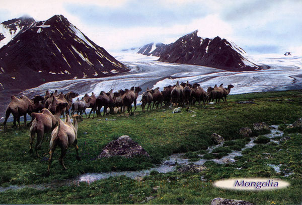
The high mountains of western and northern Mongolia experienced Quaternary glaciation. The glaciers left impressive erosional landforms as well as prominent moraines.
Bedrock Geology
The area is located within four different terranes: Harhiraa accreation terrane, Hovd turbidite terrane, Altanhohiin seamount terrane, and Lakes island arc terrane. Geologically these terranes are represented by the following types of rocks: Neoproterozoic-Early Cambrian green shale, volcanics, and limestone with archaeocyathids; Late Cambrian-Early Ordovician Gornoaltay group of monotonous green shale (plus mudstone and sandstone); Middle-Late Ordovician black shale, sandstone, and limestone with bryozoans, corals, brachiopods, and crinoids; Early Silurian green mudstone and sandstone with brachiopods, bryozoans, and crinoids; Early Devonian green sandstone and mudstone; Early-Middle Devonian gray and green sandstone and mudstone with brachiopods; Late Devonian terrigenous and volcanic rocks; Middle-Late Carboniferous coal-bearing sediments (sandstone, mudstone, and coal); Early-Middle Jurassic conglomerate, sandstone, and mudstone with flora; Late Jurassic gray conglomerate and sandstone; Quaternary glacial, fluvial, and lake sediments. Also, there are many intrusions of different granite, diorite, and gabbro complexes.
Within this area there are three active mines: placer gold at Burgastain Gol and Talyn Salaa, and the Hara Tarvagtai coal mine. The eastern part of the region is cut by a number of N-S faults some of which are terrane boundaries. The major fault in the area is the Tsagaanshiveet fault with many splays and with clear evidences of neotectonic activity. Satellite imagery and air photos indicate offset streams and probable fault-dammed lakes.
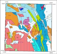
Click to load full size bedrock geologic map.
References, general
Misa, 1997, Mongolia, in E.M. Moores and R.W. Fairbridge, eds., Encyclopedia of European and Asian regional geology: London, Chapman & Hall, 540-544.
O. Tomurtogoo, ed., 1999, Geological map of Mongolia: Mongolian Academy of Sciences, scale 1:1,000,000.
O. Tomurtogoo, ed., 2003, Tectonic map of Mongolia: Mongolian Academy of Sciences, scale 1:1,000,000.
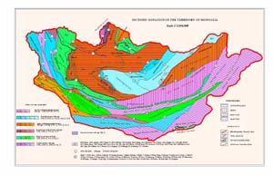
Click to load full size (again, rather large) terrane map in a new window.
References, tectonic
A.Bayasgalan, J. Jackson, J. Ritz, and S. Carretier, 1999, Field examples of strike-slip fault terminations in Mongolia and their tectonic significance: Tectonics, 18 (3), 394-411.
D. Cunningham, A.Dijkstra, J. Howard, A. Quarles, and G. Badarch, 2003, Active intraplate strike-slip faulting and transpressional uplift in the Mongolian Altay, in Intraplate strike-slip deformation belts: Geological Society, London, Special Publication 210, 65-87.
D. Cunningham, B. Windley, D. Dorjnamjaa, G. Badamgarav, and M. Saandar, 1996, A structural transect across the Mongolian Western Altay: Active transpressional mountain building in central Asia: Tectonics, 15 (1), 142-156.
References, geomorphic
Grunert, J., F. Lehmkuhl, and M. Walther, 2000, Paleoclimatic evolution of the Uvs Nuur basin and adjacent areas (western Mongolia), Quaternary International, v. 65/66, p. 171 Đ 192.
Klimek, K, 1983, Geomorphological and sedimentological aspects of Upper Quaternary changes of climate in Mongolia, in Studies in Quaternary geomorphology: Proceedings of the VI British-Polish seminar, Norwich: Geo Books, p. 169 -193.
Lehmkuhl, F., and F. Haselein, 2000, Quaternary paleoenvironmental change on the Tibetan Plateau and adjacent areas (western China and western Mongolia), Quaternary International, v. 65/66, p. 121-145.
Lehmkuhl, F., G. Stauch, and O. Batkhishig, 2003, Rock glacier and periglacial processes in the Mongolian Altai, in Phillips, Springman, and Arenson, eds., Permafrost: Proceedings of the 8th International Conference on Permafrost, v. 8, no.1, p. 639-644.
Goals of the study
- To better understand the faults of the area: type and age of motion, recurrence interval, and earthquake potential.
- To study glacial and periglacial landforms and sediments: moraines, terraces, drift, and permafrost features.
Specific problems for student research
- Geometry, kinematics, age, and evolution of the faults in the region.
- Number of glaciations, extent and age of each, climatic significance (potential correlation with glacial history determined in northern Mongolia on the 2000 expedition).
- The lakes in closed basins were likely more extensive during Pleistocene pluvial periods. Determine origins of the basins, shoreline elevations, relationship to former glaciers, climatic significance.
- Various periglacial features, their extent, origins, and climatic significance.
- Present conditions at glacial margins: glacial retreat or advance, and rates; polar or temperate glaciers; sediments and landforms at the ice margins (assuming we can get this high).
- Mineral exploration and related petrography and geochemistry (e. g., the gold and coal mines in the area).
- Possible study of fluvial, shoreline, eolian, and mass wasting processes in the area.
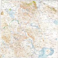
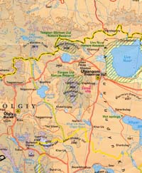
Click to load full size 1:500,000 scale topographic map of the study area in a new window.