(thediaryofpatricia.tripod.com/ id6.html)
ITALY:
June 4 - 14, 2004
(thediaryofpatricia.tripod.com/
id6.html)
___________________________________________________________________
Emily Gottesfeld '04
photos by
Corey McKrill '04
--------------------------------------
If you’d
asked me a year ago where in the world I would most like to go, Italy would
not have been at the top of the list. It’s not that I had anything against
the place; I’d just never had a burning desire to go there. In truth,
I knew little about it, and my Italian vocabulary was limited to such words
as “spaghetti,” “linguini,” “mozzarella,”
and other food-related terms. I had certainly failed to view it as geologically
interesting, aside from the (in)famous Mount Vesuvius, though this was largely
ignorance on my part, since Italy’s geology is in fact fascinating. But
in June of 2004, all this would change when Whitman geology and environmental
studies professor Bob Carson led a ten-day trip to visit five of southern Italy’s
most famous volcanoes. As a geology major with a keen interest in volcanology,
I could not pass up this opportunity.
Italy is
a geological conundrum in itself. Initially, Italy’s volcanoes were thought
to originate from the subduction of the African plate (to the south) beneath
the Eurasian plate (to the north). The simplified “textbook” explanation
of subduction says that as the subducting slab enters Earth’s semi-molten
mantle, the slab begins to melt, resulting in magma which then rises through
the crust to form volcanoes. In reality, of course, this is a great deal more
complicated. The very potassic magmatic nature of the volcanoes of central and
southern Italy, however, is not typical of subduction-type volcanoes, and some
geologists now postulate back-arc rifting as a more plausible cause, although
the possibility of crustal contamination of subduction-generated magma has not
been ruled out. Additionally, while subduction is a convergent and therefore
compressional process, GPS monitoring shows that there is active spreading and
extension in the region of the Adriatic Sea. All in all, there have been many
attempts to explain Italy’s geology, but none of them are conclusive,
and what exactly is going on remains a mystery. Suffice it to say, however,
that there are volcanoes, many of them active, so a geological something, or
perhaps many geological somethings, is going on.
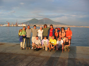
After a
long flight and very little sleep, two other Whitman students and I arrived
in Naples, where we awaited the arrival of the rest of our group, who had spent
ten days in Bulgaria and were flying into Naples a few hours later. Our first
surprise came when, as we were sitting outside the airport staring dazedly into
space, Chris and I were approached by a man who seemed to know who we were and
who introduced himself as our volcano guide, “Andrea” (pronounced
on-DRAY-uh). It took our sleep-addled brains a few seconds to process this and
come to the realization that, based on the “Andrea” we had been
corresponding with via e-mail, we had been expecting a female guide. We were
comforted to hear that this was not the first time that Andrea’s patrons
had been expecting a woman, and had a good laugh when the rest of the group
arrived, looked right past our guide, and asked, “Where’s Andrea?”
We spent
our first night in cabins at Solfatara, a 4000-year-old active volcano within
the Phlegraean Fields, a volcanic area north of Naples. Unlike most volcanoes,
Solfatara is not cone-shaped and mountain-like; rather, it is a wide, flat caldera
similar to Yellowstone, though less extensive. The smell of sulfur from the
fumaroles was overpowering, though as we discovered later in our trip this was
nothing compared to the rotten-egg stink of Vulcano. The Romans were well aware
of the beneficial properties of this natural “sauna”; the sulfurous
vapors were said to cure everything from respiratory problems to skin diseases,
and in the latter part of the 1800s two small caves were dug into the crater
wall (and later covered with masonry) above fumaroles to serve as sweat houses.
Solfatara also boasts pools of boiling mud, and in places the ground is almost
too hot to touch. Spending the night in an active caldera was exciting, though
we were reassured that, if it were about to erupt, it would give plenty of advance
warning, including rising of the caldera floor by many meters as the magma chamber
filled.
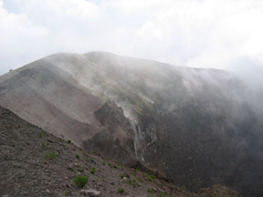
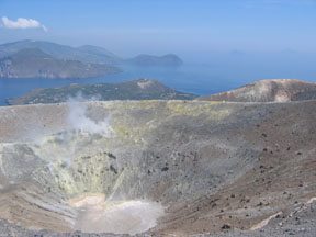
(Vesivius: Summit and Crater)
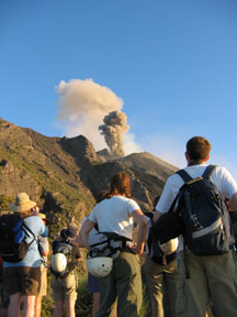
The second
day of our trip took us to Mount Vesuvius, perhaps Italy’s most famous
volcano, which in 79 AD buried the cities of Pompeii and Herculaneum during
a massive pyroclastic eruption. Vesuvius is actually comprised of two volcanoes—Monte
Somma, an ancient volcano that was much larger than the present-day Vesuvius,
and Monte Vesuvio, which grew up within the old Somma crater and which now towers
above the remains of Somma’s walls, which border it to the north and east.
Unfortunately for us, the weather was dreary, and low clouds obscured part of
the mountain. We traveled partway up the volcano by bus on a narrow, winding
road, and then hiked the rest of the way to the top, politely declining to purchase
walking sticks from vendors along the trail. We gazed into the crater from a
viewpoint, and could see within the crater walls pyroclastics and lava flows
deposited during past eruptions and exposed in cross-section, just like the
textbook illustrations of stratovolcanoes. Visitors are not usually allowed
to go to the summit, but after much haggling Andrea found a guide who would
lead us there (though a volcano guide himself, Andrea was not allowed to lead
us alone). Our guide showed us one of the many monitoring stations that keep
a constant watch for any changes in Vesuvius, including any seismic activity
and bulging or growth of the volcano, which may be warning signs of an imminent
eruption. We then ventured a very short way down from the crater rim to observe
some fumaroles, whose heat we welcomed as it was getting windy and chilly. The
rain hit us just as we reached the summit, and Bob and Andrea had to usher us
away from taking the requisite photographs of each other atop the summit, as
we were dangerously exposed to lightning. So we hurried onward around the rest
of the crater and back to the bus, stopping only to search briefly for the euhedral
(perfectly-shaped) pyroxene crystals for which Vesuvius is famous.
Vesuvius has not erupted since 1944, and based on its eruptive history has been in an overlong period of quiescence. This has led volcanologists to believe that if it should erupt today, it could produce a devastating pyroclastic eruption. It has been estimated that at least a week’s notice would be needed in order to evacuate the more than three million people who live within the volcano’s blast radius, assuming that all public transportation is up and running. Unfortunately, most of the people who live in the volcano’s shadow have come to regard it as fairly innocuous, and government-sponsored evacuation drills have failed to awaken them to the potential danger.
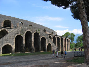
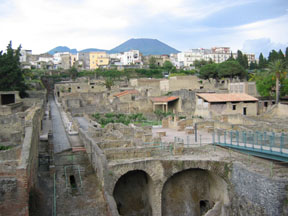
(Pompeii)
A proper
visit to Vesuvius would not be complete without visits to Pompeii and Herculaneum
as well, so we left Vesuvius just as the weather started to clear and drove
to Pompeii, where we had four hours to look around. I had not realized just
how big Pompeii is, and four hours was only a fraction of the time it would
take to appreciate the city in its entirety—akin to trying to see all
of the Louvre in a day! Pompeii is a maze, mind-bogglingly full of walls, rooms,
and narrow streets. A huge amphitheater, surprisingly intact, sits at the edge
of the city, its ancient seats now playing host to myriad wildflowers instead
of gladiatorial spectators. Many of the streets, rutted by chariot wheels, have
stepping stones over which citizens could cross so as not to set foot in the
dirty streets. Frescoes adorn walls, and intricate mosaics still decorate the
floors of the more affluent residences. Fountains, statues, and elaborate Corinthian
columns still stand in places, and clay urns can be found in abundance. Pompeii
is a marvel, for it was preserved in amazing detail by the 79 AD Vesuvius eruption,
and has been likened to a “snapshot” of a moment in the life of
a Roman city. Instead of destroying the city, the volcano buried it in pumice
and ash, which then hardened to a kind of cement, encasing and protecting all
it had buried. Most deaths in Pompeii resulted from asphyxiation by ash-laden
air and deadly gases released by the volcano’s vents, although some people
were felled by flying rocks and roofs collapsing under the weight of volcanic
debris.
Pompeii is perhaps most famous for the body casts of citizens who did not escape burial; as people and animals fell from asphyxiation, a covering of fine ash entombed them where they lay. The ashy mixture hardened around the bodies, and the peoples’ remains eventually rotted away, leaving perfect casts of them as they were at the moment of death. Archaeological excavation of Pompeii began in 1748, but was unsystematic and consisted mainly of the looting and plundering of sculptures, art, and other valuables to be sold on the black market. In 1864 archaeologist Giuseppe Fiorelli imposed more systematic methods of excavation. He discovered the casts and devised a means of forcibly injecting them with a plaster solution. Once the plaster had hardened, the volcanic casing could be removed and the plaster casts—which replicated the bodies in fine detail, including outlines of clothing, hair, and agonized facial expressions—could be removed. This unique preservation of people as they went about their lives has allowed for detailed reconstruction of both everyday life in a Roman town and an hour-by-hour account of the eruption itself. From the number of people killed, it is apparent that either Pompeii’s citizens had little time to evacuate, or failed to take the eruption seriously, as they had not witnessed such an event before. One of the most poignant of the many casts, in my opinion, is that of a guard dog who was chained to a stake, unable to escape and writhing in agony from asphyxiation and burial. Other casts show mothers sheltering their children with their own bodies, people pressing cloths to their faces in futile attempts to breathe, and groups huddled together, seeking what refuge and comfort they could.
(Herculaneum)
Herculaneum,
a seaside village much smaller than Pompeii and our final stop of the day, faced
a different, though just as intriguing, fate. Despite its closer proximity to
the volcano, wind direction spared it from the noxious gases that proved the
downfall of Pompeii. Herculaneum instead fell victim to a series of nuées
ardentes (hot, high-speed pyroclastic flows) and lahars (mudflows), which churned
down the mountainside and buried the town in up to 18 meters of consolidated
ash and debris. Many buildings and sculptures were razed to the ground, but
in some places the flow oozed more slowly into buildings without disturbing
their contents. It scorched but did not ruin cloth and wood, carbonizing it
instead. Some foodstuffs and objects, including eggshells and even wax tablets,
were preserved and remained safely buried until excavation centuries later.
It was previously believed that most of Herculaneum’s citizens managed
to escape their town’s destruction, but excavation of a boathouse in 1982
revealed hundreds of victims who fled to the shore and sought to escape by sea.
The modern-day city of Ercolano sits atop still-unexcavated portions of ancient
Herculaneum, and one wonders what undiscovered treasures may still lie buried
there.
The type of eruption that so abruptly ended the lives of the citizens of Pompeii and Herculaneum is called a Plinian eruption after Pliny the Younger, who witnessed the eruption from Misenium on the Bay of Naples and described it in great detail, providing us with the first detailed account of an eruption of this type. Plinian eruptions are explosive and catastrophic, characterized by a tall eruptive column that resembles the trunk of a tree and reaches into the stratosphere before spreading out into what, in the age of the atomic bomb, would be called a mushroom cloud. It is estimated that this particular eruption produced an ash column 33 kilometers tall, in addition to many cubic kilometers of ejecta.
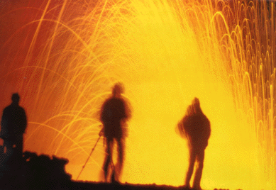
(Stromboli)
That night, we boarded an overnight ferry for the volcanic island of Stromboli, spending the night in pairs in cramped but functional cabins. We were scheduled to arrive at the island at 5:30 in the morning, and awoke early in hopes of seeing the volcano erupting, only to find that it was shrouded in mist. But we were not to be totally disappointed, for as the almost-full moon slipped away, a blood-red sun rose to greet the day. The mist soon burned off, and as we neared the island we could see steam rising from the crater. The town looked so very Mediterranean, with white stucco buildings and lush sub-tropical vegetation; this laid-back seaside village was a welcome change from the bustling metropolis of Naples and the Italian mainland. We disembarked and wound our way through narrow streets to find our hotel, a lovely place with myriad balconies and terraces and open, breezy rooms. Stromboli is currently in a state of constant eruption, and every fifteen minutes or so we would see mini-eruptions of ash and steam rise from the crater. We took a late-afternoon hike partway up the volcano’s flank (the summit was closed due to the volcano’s increased activity). The first two-thirds of the walk was along a rough cobblestone road, which Andrea informed us had been built to transport Ingrid Bergman up the mountain during the filming of the movie “Stromboli” (Bergman refused to walk). As we climbed higher, distant rumblings and a slight shaking of the ground accompanied the volcano’s periodic puffs of ash and steam. We found ourselves at a spectacular viewpoint overlooking the “Sciara del Fuoco,” a broad, steep scree slope down which rocks tumble every time the mountain shakes. The rocks, boulders really, skip and bounce down the slope, gaining momentum, before being launched into the air and arcing gracefully into the sea with great plops and splashes. As darkness fell, the eruptions became more spectacular, as the fountains of fiery lava became visible against the inky blackness. We watched in awe as the volcano erupted, each eruption sending new rocks cascading down the Sciara. After five or so eruptions, and with great reluctance, we turned on our headlamps and began the winding descent, stopping occasionally to view an eruption or watch other groups descending, their headlamps making them look like trains of fireflies. This incredible day ended with each of us eating an entire pizza for dinner, our first taste of authentic Italian pizza, so different and so much better than the doughy, soggy messes in which Pizza Hut takes so much pride.
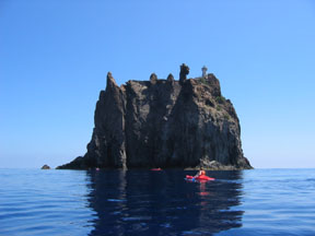
(Strombolicchio)
Just offshore
of Stromboli is Strombolicchio, the volcanic neck that is all that remains of
Stromboli’s predecessor. (A volcanic neck forms when lava cools and solidifies
in the volcano’s main conduit, and remains standing after the rest of
the mountain has been eroded away.) With the morning free, a group of us decided
to rent kayaks and make our way to this small island. The brilliant blue-green
water was so clear that we could see hundreds of tiny jellyfish floating by
(the jellyfish, or “jellies” as Andrea called them, made for interesting
swimming and a few minor stings). Getting from the kayak onto the island was
no easy task, as there is no dock but simply a staircase rising from the water.
The waves and swells made timing critical, as it was easy to capsize if you
shifted your weight at the wrong time (as I found out as we left Strombolicchio,
when I capsized twice). Navigating the stairs was made more difficult by an
angry pair of gulls, guarding their nest and dive-bombing intruders, but the
view from the top was well worth it. We then took a quick swim with the “jellies”
around the island, becoming quite startled when a spear fisherman swam by towing
a dead, bloody fish, which almost rammed us.
(Strromboli, by Clare Carson)
We spent
the latter part of the day taking a catamaran ride partway around Stromboli
to visit the town of Ginostra. This small town has only about 25 full-time inhabitants;
most of the villas are vacation homes owned by Europeans. The town only recently
acquired (solar) electricity. The vegetation here is much more desert-like,
due to Ginostra’s drier climate, and we hiked carefully around cacti and
through the tiny village to the other side of the Sciara Del Fuoco, where we
again watched rocks roll and bounce into the sea. Ginostra boasts the “world’s
smallest harbor,” located down a steep path from the village, and the
main transport of luggage and other goods to and from the harbor is by donkey.
We boarded the catamaran once again, planning to motor around to the Sciara,
eat dinner, and once again watch the volcano erupt by night. The boat’s
engine refused to start, however, and it took the better part of an hour to
get it going again, with everybody giving it a try. We started to set off, only
to find that our anchor was stuck, and Antonio, our captain, reluctantly had
to cut the rope. By the time it was fully dark (after another spectacular sunset),
I was torn between what to look at—the volcano’s glowing eruptions,
the innumerable unobstructed stars, or the bioluminescence caused by microorganisms
in the water. We stirred the water to enhance this effect and watched jellyfish
glide by, outlined in an eerie green light.
In the morning
we left Stromboli with much regret, traveling by hydrofoil (basically, a boat
on skis) to the larger and more touristy island of Lipari, another of the Aeolian
Isles. We did some preliminary exploring of the town, visiting some interesting
museums and an exquisite old church. Andrea then led us on a walk through pumice
and obsidian flows; the pumice, which is hundreds of feet thick in places, is
mined there.
(Vulcano)
We boarded
a small motor boat the next morning for a boat tour of Lipari’s coast,
including sea stacks, sea caves, and many more opportunities to swim with the
“jellies.” We continued on to Vulcano, the type locality for which
all volcanoes are named, and hiked to the top of this perfectly conical, fairly
small volcano. The sulfurous gas from the fumaroles along the crater rim was
overpowering, stinging our eyes and burning our throats, but we braved it in
order to closely examine and collect samples of the neon yellow sulfur crystals
that formed around each vent. The crater itself is perfectly circular and equidimensional,
in Bob’s words a “textbook” example. We ascended a well-maintained
trail, but for our descent Andrea taught us how to “glissade” down
the scree slope by bending our knees, rocking forward, and bounding down the
mountain in great leaps, one foot at a time, planting heel first and sliding
a distance on the loose rocks before leaping again. Tremendous fun! Near the
foot of Vulcano is a large mud pit, which is prized for its therapeutic properties,
and a great number of people were wallowing around in it, covered in mud and
stinking of sulfur.
The next
morning we boarded yet another ferry for our final destination: Sicily. From
there, we piled on to a bus and drove to our next accommodation, the “northern
refuge,” a cozy hotel partway up Mount Etna’s north slope. Just
up the road from the hotel is some derelict vacation property and an old wall,
shaken and cracked by an earthquake and overrun by a lava flow a couple of years
ago. The real effort began the next day, when we set out for an all-day hike
partway around and up the mountain. We encountered multiple basalt flows, dating
from the early 1900s to the more recent 2001-2002 flows. The majority of the
lava is of the aa type, sharp and jagged, but we also encountered some ropy
pahoehoe lava, smoother and resembling giant cow pies or the crinkled skin on
partially-cooled custard. A cross-country hike across the lava took us to a
lava tube, which blasted us with frigid air as we descended into its mouth.
After following the cave for quite a length and marveling at the “lavacicles”
on the ceiling, we gladly re-emerged into the warm outside air. We continued
through the lava fields, climbing up and around cinder cones and examining volcanic
bombs of all types and sizes. One of the more interesting volcanic features
is “La Boutonniere” (“the buttonholes”), a straight
line of small craters and spatter cones that, from above, resembles the buttonholes
on a shirt. We wended our way onward and upward, and eventually found ourselves
amidst some barren white-gold trees, stripped of their leaves and bark and killed
by the lava that had engulfed their roots. They stood out in sharp contrast
against the black lava; some of the trees even had lava bombs nestled in their
branches, where they had been caught as they fell. Farther on we came to what
(little) was left of the ski resort, which was overcome by the most recent lava
flow. Just the tops of the chairlift towers stuck out above the lava, attesting
to the thickness of the flow. A resort hotel was bulldozed, twisted, and almost
completely buried, and the street of shops and restaurants was gone entirely.
Ironically, they were already in the process of re-building the lifts and ski
runs, despite the fact that these will almost certainly be destroyed again in
the next eruption.
 |
 |
(Mt.
Etna: North Flank) |
(Mt.
Etna: Summit) |
After dinner,
Andrea led a small group of us on a short walk to a viewpoint from which we
could look down on the lights of the Sicilian city of Catania. We sat in silence,
reflecting on the past few days and wishing it could last forever. Thus ended
the last night of an extraordinary trip, one which will never be forgotten and
which helped me fall deeply in love with Italy.
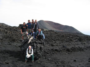
( Accretionary Lava Ball
Mt. Etna, South Flank)
------------------------------------------------------------