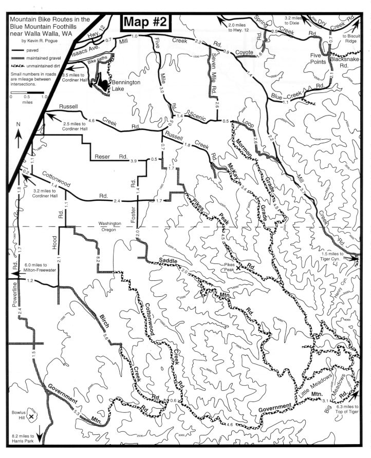
If you wish to ride directly from Walla Walla, and don't want an overly long approach to the mountains, you can choose from a number of dirt roads, the "foothill grades", which follow ridges that ascend directly out of the wheat fields of the Walla Walla valley (see map #2 for location of the foothill grades). All of these routes are very strenuous and involve long stretches of moderate to steep climbing on less than ideal surfaces. In general, the condition of the roads depends on when they were last graded and whether or not they were deeply rutted by 4-wheelers during the rainy season. All of the foothill grades eventually lead to Little Meadows and Big Meadows which comprise a relatively flat, grassy plain on the crest of the ridge that lies between Walla Walla and the valley of the North Fork of the Walla Walla river. Much of this area area is private land (some of which is posted) and all of the area is crisscrossed by a maze of logging roads and four-wheel-drive trails. It is very easy to get lost if you venture off of the main roads. It is possible to connect any of the foothill grades to the top of Tiger Canyon Rd. via Government Mountain Rd. Access the foothill grades from downtown Walla Walla by following Park St. to Howard St. For detailed access information consult the foothill grades map (map 2). A brief description of the foothill grades from south to north follows below.
Foothill Grades Descriptions
Access: via Powerline Rd.
Road surface: gravel and rocky dirt
Steepness: climbs 1620 ft. in 5.3 miles (Powerline Rd. to intersection with Birch Creek Rd.): avg. grade = 5.8%
Loops: See ride #3, also with Birch Creek Rd. via Powerline Rd.
General comments: This road is better maintained than any other foothill grade. Deep, loose gravel is occasionally a problem on the lower section. Steeper sections may be somewhat rutted with some larger loose rocks. The start of this road is a long ride (10.6 miles) from Walla Walla relative to the other foothill grades.
Access: via Powerline Rd.
Road surface: paved to intersection with Hood Rd. The lower gently-sloped section is maintained gravel. The upper steep section is rutted dirt and rocky dirt with some very rocky sections.
Steepness: climbs 1853 ft. in 5.6 miles (Hood Rd. to intersection with Government Mountain Rd.): avg. grade = 6.3%
Loops: See ride #3, option 2, also with Government Mountain Rd. via Powerline Rd.
General comments: A long very rocky steep section in the middle of this road is very difficult to ride. Most cyclists would choose to walk this section. It's not even much fun to descend. Cottonwood Creek Rd. and Government Mountain Rd. are better rides.
Access: via Hood Rd.
Road surface: paved to intersection with Hood Rd. Lower gently sloped section is maintained gravel. Upper steep section is rutted dirt and rocky dirt with some very rocky sections.
Steepness: climbs 1840 ft. in 5.8 miles (end of maintained gravel to Government Mountain Rd.): avg. grade = 6.0%
Loops: See ride #3. Also possible to loop with Saddle Mountain Rd., Pikes Peak Rd., or McKay and Mormon Grades via Government Mountain Rd. and Little Meadows.
General Comments: This is the best of the foothill grades south of Mill Creek. The start is relatively close to town, the road surface is relatively smooth, and the steep sections are neither too long nor too steep.
Access: via Foster Rd.
Road surface: rutted and rocky dirt
Steepness: climbs 1392 ft. in 2.0 miles (Foster Rd. to gate at ridge crest): avg. grade = 13%
Loops: Can connect to Pikes Peak Rd., McKay Grade and Mormon Grade through the Little Meadows area and to Cottonwood Rd. and Birch Creek Rd. via Government Mtn. Rd.
General Comments: The first two miles are unrelentingly steep and rocky. If you survive the initial climb, you'll enjoy the upper part which climbs gently as it contours around the south side of Saddle Mountain en route to Little Meadows.
Access: via either Cottonwood Rd. or Foster Rd.
Road surface: varies from very rocky dirt on the steep climbs to smooth dirt on the rare level sections.
Steepness: climbs 2537 ft. in 6.1 miles (Foster Rd. to ridgecrest intersection): avg. grade = 7.9%
Loops: You can easily connect with McKay Grade and Mormon Grade by turning left at the major intersection at the top of the climb. It is also possible to link up with the foothill grades farther south by turning right at the top intersection and working your way toward Little Meadows through the maze of logging roads.
General Comments: Due to its proximity to town and its reputation as a brutal hill climb, Pikes Peak Rd. sees more ascents than the other foothill grades. However, it is not one of the more user-friendly of the foothill grades. Some of the steeper sections are so rocky they are almost impossible to ride. If you want a more aesthetic experience try Cottonwood Creek Rd. If you really want a brutal climb, try McKay Grade.
Access: via Russell Creek Rd.
Road surface: very rocky dirt on lower section, rutted somewhat rocky dirt on upper section.
Steepness: climbs 2121 ft. in 3.4 miles (Russell Creek Rd. to ridgecrest intersection): avg. grade = 11.8%
Loops: Easy to loop southward to Pikes Peak Rd. by turning right or northward to Mormon Grade by turning left at the upper intersection.
General Comments: An ascent of this monstrosity is best described as a"puking grunt" and is better left to masochists. Baseball- and softball-sized rocks litter this rutted, relentlessly steep, poor-excuse for a jeep trail.
Access: via Scenic Loop Rd.
Road Surface: Lower one-third is good gravel, middle one-third is very rocky dirt, upper one-third is somewhat rocky dirt and smooth dirt.
Steepness: climbs 1951 ft. in 4.5 miles (Scenic Loop Rd. to ridgecrest): avg. grade = 8.2%
Loops: Descend McKay Grade by turning right at the first major intersection. Descend Pikes Peak Rd. by turning right at the second major intersection. See ride #4 to connect to Tiger Canyon.
General Comments: This would be a good ride if the middle section wasn't so rocky. The fine views down into the valley of Mill Creek help take your mind off the rocks. A better ride than Pikes Peak Rd.