Rock Climbing Guide to the Dikes
Introduction
For photos click here.
Are you looking for towering near-flawless walls of impeccable stone? Or perhaps, continuous clean crack systems that just beg you to insert your appendages? Well then look somewhere else dammit! These are THE DIKES, for heaven's sake! If you are a rock snob who looks down your nose at "chossy" rock, that is occasionally loose, sometimes mossy or dirty, and contains no continuous crack systems, STOP READING NOW!
OK. Now that we've gotten rid of the rock snobs, I can talk to the rest of you adventurous types who realize that well-rounded climbers enjoy a broad spectrum of vertical terrains, not limiting themselves to "ideal" conditions (rock snobs could have never conquered the Eiger Norwand!).
Here are a few things that you should know about the climbing at The Dikes. The rock is basalt. However, it is NOT composed of vertical columns separated by continuous vertical crack systems like many other basalt climbing areas (e.g. Frenchman Coulee, The Gorge at Smith Rock, Beacon Rock, etc.). Columns, where present, are horizontal and have a much smaller diameter. As a result, the fractures are very closely spaced and the cliffs are littered with loose chunks that are easily detached. Every route requires extensive loose rock removal and it is sometimes difficult to find rock competent enough to accept a bolt. Despite the considerable amount of time spent preparing new routes, it is still possible (even probable) that you will encounter loose rock. If you get off route (more than 3 ft. to either side of a line connecting the bolts) you will certainly encounter copious amounts of loose rock, dirt, moss, and lichen.
Due to the rock fall potential, it has been said that it is more dangerous to belay than to climb at these areas. Helmets (and quick reflexes) are mandatory for the belayer. If possible, belayers should position themselves out of harm's way. Having established many routes at both Frenchman Coulee and at the areas described herein, I can confidently say that the rock at Frenchman coulee is the more "chossy" (more fractured and loose). Rock fall on the popular routes at Frenchman coulee has only diminished in recent years due to the high frequency at which they are climbed. Unfortunately, the "off the beaten path" nature of the climbs in this guide will probably insure that belayers will be dodging rocks for many years to come.
At this point, you may be asking yourself "why should I climb at this choss pile?" My answer is that you shouldn't, unless you are prepared to accept the risks. All rock climbing involves taking risks and in the areas described in this guide the risks of being injured by a falling rock are greater than at most other crags. Also, I've told you exactly what it's like, so don't come complaining to me if your noggin gets bonked, or your handhold breaks off, etc, etc. So why do I climb at these areas? Here are my reasons:
1) The climbing is close to Walla Walla.
2) It is often possible to climb comfortably in the sun when lower elevations are foggy and cold due to wintertime temperature inversions.
3) Some areas remain shady and comfortably cool even when it's over 100° in Walla Walla.
4) The climbing is only a 1-hour drive from Walla Walla.
5) Climbing loose rock adds another element of excitement to an already exciting sport.
6) Some of the routes end on the summits of pinnacles that can only be ascended by 5th class climbing.
7) It is possible to leave Walla Walla at noon, knock off a few routes, and be home for dinner.
8) Some of the routes are actually pretty solid.
9) Several of the routes are perfect for beginners (or girl/boy friends). The Dikes has better beginner routes than Spring Mountain.
10) Solitude. It is doubtful that you will encounter another person while you are there.
11) The views.
12) After a tough day of climbing and rock-dodging relax and have dinner at Jimgermanbar (Jim is undoubtedly the best bartender in the world) or the Whoopemup Cafe in Waitsburg.
13) Since the access road is plowed, it is possible to climb both earlier and later in the year than at Spring Mountain.
14) You save three hours of driving time compared to a trip to Frenchman Coulee.
15) Some routes are longer and others more exposed than any of the routes at Spring Mountain or Frenchman Coulee.
The reasons listed above could be summarized as "it's close, it's accessible, and it's fun". If after reading this introduction, you decide to check it out, have fun and be safe.
The Climbing Areas
This guide contains information on four climbing areas: The Dikes, Joe's Rock, Weeping Wall, and The Castle. All of the areas are located in the Walla Walla Ranger District of the Umatilla National Forest in the valley of the East Fork Touchet River within a few miles of the Middle Point Ridge trailhead. To get there from Walla Walla, head east on US Hwy. 12 to Dayton (see map 1). Turn right (south) at Dayton just past the PDQ Chevron Mini-Mart, where a sign points the way toward Bluewood ski area. The Touchet River valley gradually becomes steeper and narrower as you drive upstream. Between 16 and 17 miles from the turn at Hwy. 12, you will reach the Middle Point Ridge trailhead parking on the left (east) side of the road (see map 2). The directions to the parking spots for the various crags are referenced from this point, so set your trip odometer to zero here.
The Dikes
The Dikes are fin-like crags of basalt that protrude from the steep eastern flanks of Chase Mountain in the valley of the East Fork of the Touchet River (see map 3). They originated as igneous intrusions, cracks in older lava flows that were filled with basaltic magma. These magma-filled cracks were some of the conduits that supplied molten rock to the voluminous volcanic eruptions that produced the Columbia River flood basalts. After the eruptions ceased, the magma within the cracks slowly cooled and hardened into basalt that is slightly more coarse-grained and generally less fractured than the lava flows it intruded. Due to these textural differences, the rock comprising The Dikes is more resistant to erosion than that of the surrounding lava flows. As the Blue Mountains were uplifted, streams such as the Touchet River eroded steep valleys into the thick accumulations of Columbia River Basalt. Since the more resistant rock of The Dikes weathers and erodes at a slower rate than the lava flows, it eventually sticks out of the hillside, producing a large fin of rock.
When most people think of basalt, they picture the spectacular columns commonly exposed in the canyons of the Columbia River and its tributaries. These columns are usually oriented vertically because the cracks, called joints, that delineate them propagated vertically away from the surface of the lava as it cooled and contracted. Molten rock below the ground (magma) also fractures as it cools, contracts, and hardens against the surrounding rock. The joints slowly propagate into the interior of the intrusion, producing a network of cracks that are perpendicular to the boundary between the intrusion and the surrounding rock. In the case of The Dikes, the walls enclosing the magma were vertical, so the joints propagated horizontally, breaking the rock into horizontal columns that resemble stacks of firewood. "Cordwood" jointing, as it is known is characteristic of vertical dikes throughout the world. For climbers, this pattern of jointing means that the climbing on the edges of a dike is very different from climbing on the sides.
Four north-trending dikes cross the Touchet River road between the Middle Point Ridge trailhead and Bluewood Ski area. Almost all of the climbs have been established on two closely spaced dikes that intersect the highway about 1.5 miles above the trailhead. The eastern of these two dikes is called the "megadike" because it is the longest and thickest dike in the valley. The smaller western dike is the "minidike". Erosion has breached both of these dikes at many points, breaking the formerly continuous walls of rock into discreet triangular fins like those on the back of a dragon. A few of these breaches allow a hiker to pass from one side of the dike to the other, but most are too steep. To access the climbs on the northern part of the megadike (see map 4) (The Dragon's Back and Cordwood Tower) park 1.1 miles past the Middle Point Ridge trailhead where a dirt road intersects the paved road on the left (SE side). Cross the main road and look for the beginning of the approach trail (route A, map 2) where a culvert passes beneath the road. To access the climbs on the south part of the megadike ( see map 5), drive 1.2 miles past the Middle Point Ridge trailhead and park on either side of the road just before a bridge over the river. Scramble up the steep hillside on the NW side of the road above the bridge abutment. After you intersect the dike, keep scrambling uphill (route C) until it is possible to cross through the dike via a steep gully. Branch off to the left early (on route D) to reach Roadview wall. In early season, follow the more exposed (and snow-free) ridgeline to the east (route B) to reach the Febmar wall. To reach the Minidike (see map 6), park 1.5 miles past the Middle Point Ridge trailhead on the left (SE) side of the road, just after crossing a bridge over the river. Walk across the road, scramble down the abutment, and follow a trail (route E) downstream on the NW side. A steep uphill trail that leads to routes on the west side of the minidike branches off just before the Local Boy's wall comes into view.
Joe's Rock
Joe's Rock is a rather small erosional remnant of a dike situated on the south bank of the East Fork Touchet River (see map 2). It is shaped like a large boulder rather than a fin. Smaller remnants of the dike that forms Joe's rock extend both up the hill south of the rock and across the road north of the rock, but unfortunately, none are big enough to offer any more climbing opportunities. To reach Joe's Rock drive 2.0 miles past the Middle Point Ridge Trailhead until you see the rock on the left. The top of the rock is approximately level with the road. Park in a wide spot on the left side of the road and scramble down a gully/streambed and cross the river on stepping-stones. This stream crossing is only possible after snowmelt runoff has dissipated. In early season it is sometimes possible to find a downed tree that bridges the river. The staging area for climbing is an idyllic mossy meadow by the babbling stream. It is delightfully cool on hot days. There is presently only one route on Joe's Rock and one abandoned project (have at it!).
Weeping Wall (Ice)
Weeping Wall is a 40-50 ft. high cliff formed by erosion of the basalt bedrock by the East Fork Touchet River (see map 3). In places the river has undercut the cliff so that it overhangs. The rock itself is exceedingly fractured and unsuited for climbing. About 40 feet above the river, a series of springs issues from a ledge that marks the boundary between two basalt flows. The springs seep down the cliff and drip into the river below. In winters that are both cold and wet enough, the water streaming down the cliff freezes thick enough to climb. Once formed, the ice often persists for weeks due to its permanently shaded location. A series of 6 double bolt anchors have been installed along the ledge to facilitate descents and top-roping. It is sometimes necessary to chip through 6-8 inches of ice to reach the anchors. If you want to set up top-ropes and don't want to lead-climb the ice, you can walk around the right side of the cliff and rappel down to the ledge from trees on the hillside above. The ice climbing increases in steepness and difficulty moving from right (WI2) to left (WI5) across the cliff. In good ice years it is possible to climb large icicles that overhang the river. To reach Weeping Wall drive 1.1 miles past the Middle Point Ridge trailhead. The ice should be obvious (if it's there). Park on the left where a dirt road intersects the main road. This is also the parking area used to access climbs on the northern part of the megadike.
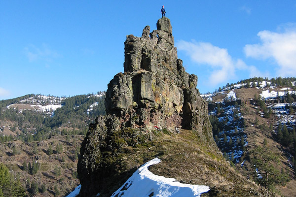
The Castle
The Castle (photo here) is a small pinnacle of rock about 45 feet high that is situated on the crest of a ridge just west of the confluence of Spangler Creek and East Fork Touchet River (see map 2). Unlike the other rock climbing areas in this guide, the Castle is not eroded from a dike; it consists of parts of 3 lava flows of the Columbia River basalt. The short vertical columns at the base of the flows is dense and hard, while the rock in the upper part of each flow is more fractured and full of small holes called vesicles, produced by gas bubbles in the lava.
To reach The Castle, drive to the Middle Point Ridge trailhead, turn around, and head back down the road. After 0.6 mile, the Castle is visible straight ahead atop a ridge. If, after this imposing view, you are not too intimidated, drive another 0.6 mile and park on the right (east) side of the road where a dirt road from Spangler Creek valley intersects the main road. Cross the main road and make your way up a long and very steep hillside to the base of The Castle. All of the routes are on the south side and all were established on sunny, 50°+ winter days when Walla Walla was foggy and below freezing.