Name of area: Bulo Point
Where: south of Hood River, OR
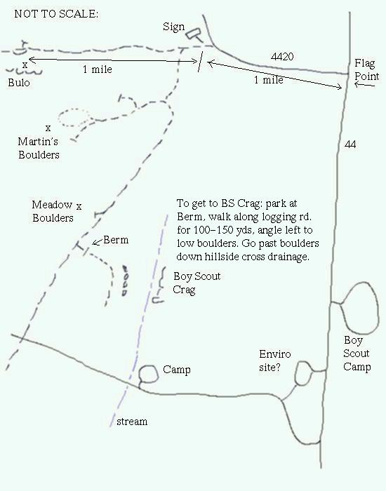
How do I get there from Walla Walla?: Take Hwy. 12 toward Tri-Cities. At Wallula Gap head south on Hwy. 730 toward Umatilla. Stay on 730 until it intersects I-84. Head west on I-84 until you reach exit 64 at Hood River. Take Hwy. 35 south toward Mt. Hood. Turn left after 20-25 miles on Road 44 toward Dufur. After 8 miles turn right on forest service road 4420 at the Flag Point sign. Go one mile to where the road bends right and a dirt road goes straight - go straight - there's a sign saying something like "Dufur City watershed". Follow the dirt road for another mile until you reach a small turnout on the right and a well-worn path on the left leading to the top of the crag in 100 yds. and park on the right. The crag is on the north edge of the Flag Point 7.5 min. topo map on the northern boundary of sec. 30, T2S, R11E.
Click here for a map of the climbing areas near Bulo Point, courtesy of David Sowerby.
How long of a drive is it? 3.5-4 hours
What's there?: Volcanic rock cliffs of moderate (half-rope) height with numerous routes both trad and sport at elevation of 4600 ft.
Land Ownership: Mt. Hood National Forest
Pros:Good rock, easy to top-rope, nice scenery, on the way to Mt. Hood, not too far out of the way when travelling to or from Portland.
Cons: Wet weather, no guidebooks, snowed in November through April
Comments:I'll let you know more after I check the place out myself.