2002 Keck Consortium Junior Research Project
Title: Geology of Castle Rocks State Park and Vicinity, southern Idaho
Project director: Kevin Pogue, Whitman (structural geology, tectonics)
Other faculty: Doug Clark, Western Washington (glacial geomorphology), Bob Carson, Whitman (geomorphology)
Number of students: 9
Dates: June 23 – July 20, 2002
General geology
(derived from many sources referenced in the previous investigations section)
The Castle Rocks lie within the core of the Albion Range metamorphic core complex, part of the belt of highly-extended Cordilleran core complexes within the Basin and Range province. Rocks exposed in the Albion Range record most of the major tectonic events that affected the western United States. The oldest rocks are basement gneiss and schist of the Green Creek Complex, part of the Archean Wyoming province. The basement rocks are overlain by low-grade Proterozoic metasediments deposited during the initial rifting of the Cordilleran passive margin. Shallow water sedimentary units were deposited along the new margin during the Paleozoic and Mesozoic, prior to Late Jurassic to Cretaceous compressional deformation associated with the Sevier orogeny. This part of Idaho was in the hinterland of the main Sevier thrust belt and shows evidence of both compression and extension during the late Mesozoic. In the Oligocene, the Almo pluton intruded the rocks now exposed in the Albion Range. During and after emplacement of these granitic rocks, the region was dramatically uplifted and extended, and the rocks overlying the granite were deformed by large scale ductile shear zones. Extension continued throughout the Cenozoic and the rocks were uplifted to form three large-scale structural domes. Bimodal volcanics associated with the passage of the Yellowstone hotspot blanketed the Albion Range region during the Miocene. The most recent extension is along high-angle late Quaternary range-bounding normal faults. The highest points of the Albion Range, Mt. Harrison (9,265') and Cache Peak (10,339') hosted alpine glaciers during the Pleistocene. Deep erosion by streams and glaciers along the crest of the range has exposed the Archean Green Creek Complex and the Almo pluton in the core of the structural domes. The granitic rocks of these units have been eroded into a spectacular landscape of fins and spires.
Recent History
Castle Rocks State Park is a new addition to the Idaho State Parks system. It is scheduled to be opened to the public during the summer of 2002. The creation of the park is the result of a collaboration between private landowners, the Conservation and Access Funds, and several state and federal government agencies. The geology and topography of the Castle Rocks is similar to the nearby City of Rocks National Reserve, but the Castle Rocks were privately owned until very recently. As no geologic studies have focussed on the Castle Rocks Basin, geologic information to help guide decisions regarding theplacement of trails, preservation of unique or significant features, etc. is unavailable to park management.
Previous geologic investigations
The deformational history of the Albion Range and nearby Grouse Creek-Raft River metamorphic core complexes has been the subject of many published papers. Armstrong (1968) was the first to describe, name, and date the major units of the Albion Range. Compton (1983), Covington (1983), and Todd (1980) focused on the regional-scale structures and the timing of deformation in core complexes of the Idaho-Utah border region. Miller (1980) concentrated on the detailed structure of the structural domes of the northern Albion Range. The general geomorphology of the City of the Rocks was described by Cunningham (1971). R.L. Armstrong mapped the entire Albion Range at a scale of 1:24000 during the 1970's and early 80's. Unfortunately, he died before his field maps could be compiled and published. Using Armstrong's maps and additional geologic mapping, the Almo quadrangle, which includes the City of Rocks National Reserve, was recently completed by David Miller of the USGS and Marsha Davis of the National Park Service.
Geologic problems to be addressed by the study
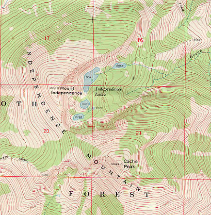
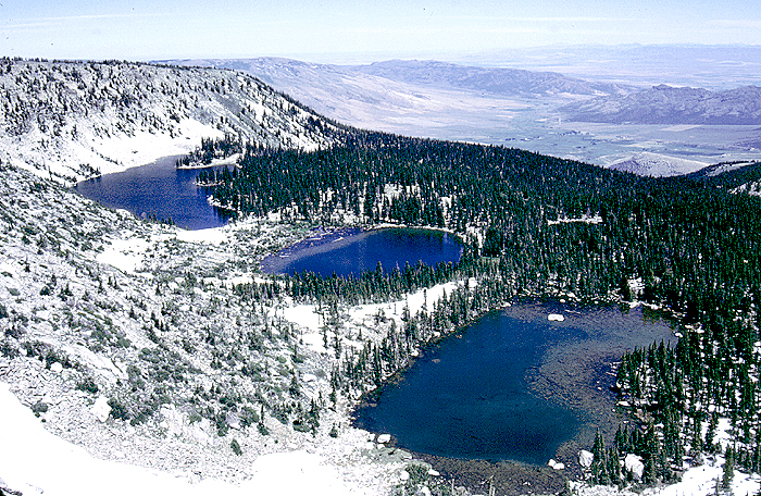
Castle Rocks is a bizarre landscape that includes fins, spires, hollow boulders, deep weathering pits, natural arches, and other unusual features that have resulted from many processes including, weathering along joints, faults, and dikes, case-hardening, "sapping" by groundwater, hydrothermal alteration, and wind erosion. The granitic landforms lie in the floor of a large basin rimmed by outcrops of more resistant Precambrian rock. The north side of the basin is formed by the southern flanks of 10,339’ Cache Peak. There are many problems associated with the developent of the unusual landfoms present at Castle Rocks and with the glacial history of the adjacent high peaks of the Albion Range. The structural relief and variety of lithologies in the Albion Range make for fascinating geomorphology. Obvious on the topographic maps are the compound cirques on the northeast sides of Mount Harrison and Cache Peak, and one or two poorly developed cirques on the south side of each peak. Armstrong (unpublished geologic map of Cache Peak quadrangle) indicated widespread "Qg"; if this is mostly till, there is the hint of a small mountain ice cap. His map has symbols suggesting moraines as low as 6300'; this would make the Pleistocene ELA (equilibrium line altitude) at about 7500'. These symbols indicate three possible moraines at 7800' to 9000' near and below the five tarns/paternoster lakes on Independence Mountain. To the best of our knowledge, no other glacial work has been done in this area.
Specific problems include:
1) What controls the distribution of the individual rock formations? petrologic variations?, joint density?, faulting?, climatic variations (aspect, altitude, etc.)?
2) What controls the shape of individual rock towers?
3) How does case hardening develop? What is its composition?
4) How do hollow boulders and weathering pits develop? What controls their size and distribution?
6) Are the major joint systems related to cooling, exhumation, or regional tectonic stresses?
7) Are faults present within the pluton? What is their sense of motion? What can they tell us about the relative magnitude and timing of extension?
8) How long does it take to create unusual features such as case hardening and hollow boulders?
9) What is the chronology of Quaternary glaciation in the Albion Range?
10) What is the origin of large elongate relatively low-elevation landforms mapped by Armstrong as glacial deposits?
11) What is the origin of the large scale terrace-like landforms on the western slopes of the Castle Rocks Basin
12) What is the origin of the “potholes” that are mapped on the northwestern flanks of Cache Peak?
13) What are the timing and mechanisms for the large landslides?
Goals of the Study
1) To increase the understanding of the formation of the unusual landscape of the Castle Rocks and the glacial history of the Albion Range
2) To provide the management of the state park with information that can be used to guide decisions and develop interpretive resources.
Methodology
To answer questions such as those proposed above, we would:
1) Identify and describe major joint, fault, and dike systems and map them at a relatively large scale
2) Measure and describe various shape parameters of individual formations at various elevations and aspects
3) Compare the weathering characteristics of glaciated and unglaciated granite to try to gauge the timing of the weathering processes
4) Collect data regarding tower distribution and joint density
5) Analyze aerial photographs for joints and faults and search for relative motion indicators
6) Describe the variations in weathering characteristics between the Archean granitic gneiss and Oligocene granite.
7) Conduct surficial geologic mapping, particularly as it relates to the extent of glaciation
8) Study the soils on the various moraines, and, together with possible surface exposure dating using cosmogenic isotopes, attempt to develop a chronology for glaciation
9) use air photographs to map and describe the landslide and terrace-like landforms and their associated bedrock structures.
Logistics
Project participants and rental vehicles would be picked up at the Salt Lake City airport. The field site is approximately 3.5 hours drive northwest of Salt Lake City. Accommodations would be in a rented house in the small town of Albion, 30 minutes drive from the field sites (map) (Acrobat Reader required).
Letter for project participants
References
Armstrong, R.L., 1968, Mantled gneiss domes in the Albion Range, southern Idaho: Geological Society of America Bulletin, v. 79, p. 1295-1314.
Compton, R.R., 1983, Displaced Miocene rocks on the west flank of the Raft River-Grouse Creek core complex, Utah, in Miller D.M., Todd, V.R., and Howard, K.A., eds., Tectonic and stratigraphic studies in the eastern Great Basin: Geological Society of America Memoir 157, p. 271-280.
Covington, H.R., 1983, Structural evolution of the Raft River Basin, Idaho, in Miller D.M., Todd, V.R., and Howard, K.A., eds., Tectonic and stratigraphic studies in the eastern Great Basin: Geological Society of America Memoir 157, p. 229-237.
Cunningham, F.C., 1971, The Silent City of the Rocks, a bornhardt landscape in the Cotterral Range, south Idaho, USA: Zeittschrift fur Geomorphologie, v. 15, p. 404-429.
Miller, D.M., 1980, Structural geology of the northern Albion Range, south-central Idaho, in Crittenden, M.D., Jr., and others, eds., Cordilleran metamorphic core complexes: Geological Society of America Memoir 153, p. 399-423.
Todd, V.R., 1980, Structure and petrology of a Tertiary Gneiss dome in northwestern Utah, in Crittenden, M.D., Jr., and others, eds., Cordilleran metamorphic core complexes: Geological Society of America Memoir 153, p. 349-383.