ACONCAGUA, ARGENTINA
12-17 January 2009
Bob Carson
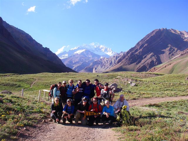
Monday: After spending Sunday night in Hotel Ayelen at Los Penitentes (elevation 8468 feet), 12 Whitman students and I drove three hours to Mendoza (elevation 2449 feet) to change dollars to pesos to purchase Aconcagua permits. We rejoined our lead guide, Juan Villagra, there, and met Herrardo Castillo, also of Andes Mountain Guides (based in Bozeman, Montana), who was very helpful with logistics. As ever, Natalia Martinez, who lives in Patagonia where we have been for a week, was with us. After a pizza lunch, we returned to the crest of the Andes, specifically the Horcones Ranger Station (elevation 9384feet). At this trailhead we were briefed by a ranger, filled our water bottles, and hiked north up the Horcones Valley. The Aconcagua region is quite dry, but there are beautiful yellow and purple flowers near two small lakes. We ooed and awed over the view upvalley of Aconcagua, with no clouds in the sky. The north (elevation 22831 feet) and south peaks are the highest in the western and southern hemispheres.
 |
The trail goes up and down, with only one long ascent. We crossed the Horcones River on a suspension bridge; the river runs red with silt from the Mesozoic red beds. Huge boulders of volcanic breccia lie in the valley, part of the andesite Aconcagua volcanic complex of Miocene age (15 to 9 million years old). We soon discovered dark volcaniclastic sandstones (and conglomerates), probably distal fluvial facies of the lahars that emplaced the breccias. Many of the rocks are vertical; some are folded. Light-colored thick trachytic dikes (and sills) (15 million years old) shoot through the Mesozoic red beds and limestones (the beautiful banded Cretaceous limestones locally contain chert).
All around are colorful jagged peaks with snowfields. Abundant moraines with green grassy hummocks cover much of the valley floor, including the location of Camp Confluencia (elevation 10892 feet) which we reached at nearly dark (9:10 pm) after almost three hours of hiking. This luxurious camp is five miles from the trailhead: big tents with double- and triple-decker bunks with mattresses, cook tents, dining tents, toilets, even showers. Photovoltaic panels and batteries provide electricity for compact florescent lights. A very bright Venus in the west was replaced with a just-past-full moon in the east after we bedded down.
Everyone did very well ascending this evening, no altitude problems yet. There are lots of mules carrying gear (including ours) between the ranger station, Confluencia Camp, and Plaza de Mulas camp (elevation 14025 feet). Mules make for light loads for trekkers. The many attempting to summit Aconcagua won’t get mule support above Plaza de Mulas.
Tuesday: I woke to brilliant stars, and then early dawn, and then sunlight and a warm day. The skies are deep blue, with only a few clouds all day. Magnificent peaks with small glaciers are in all directions, and look nearly impossible to climb. Breakfast was at 9; we hit the trail a little after 10. First we hiked to the junction of the two major valleys, where I was surprised to note stagnant ice with insulating drift.
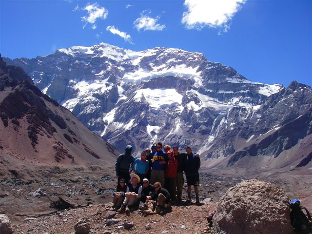 |
Our route was north in the Horcones Inferior Valley, full of fascinating rocks and minerals, including layered mafic rocks (likely the magma chamber for the Aconcagua Volcanic Complex) and giant gypsum crystals (Mesozoic in age). The center of the valley has a large stagnant glacier (Horcones Inferior) with thick debris, some ice seracs, and melt water ponds. Immediately east is a young mudflow deposit. On the valley sides are lateral moraines (probably from the Little Ice Age). The valley walls have steeply dipping rocks of many colors. The trail had three parts: first up and down, then a long ascent, then a very gradual ascent to the knoll with what has to be one of the most magnificent views on Earth. The foreground is the Horcones Inferior Glacier, perhaps completely stagnant (it is estimated than 80% of the ice in the Andes will be gone in 20 years). Rising 10,000 feet (3 km) above the glacier is the south face of Aconcagua! Ledges have small hanging glaciers; ice, snow, and rock fall on each other. Juan and Natalia each plan to climb this very dangerous route, with one other person. Their plan is to climb Aconcagua by the normal route two or three times to get acclimatized (if guiding, this could be ten days per trip). They will attempt the south face from Plaza Francia (just beyond our viewpoint) in two days, with a bivouac half way up. The will have very light loads, maybe one sleeping bag and no tent. The descent might be at night, via the normal route. Fewer than 100 people have ever climbed the south face of Aconcagua.
We admired the view for almost two hours, including lunch, photos and even naps in places sheltered form the strong wind. It took us almost four hours to ascend to our lookout at 13090 feet, and less than three hours to return to Confluencia camp. The wind prevented the day from being too warm for out hiking.
At camp we had snacks, and an hour later a dinner of pasta and meat. We drank lots of fluids; a few of us got headaches today from the altitude and the sun. We are supposed to visit the camp doctors here and at Plaza de Mulas; they check breathing, pulse, blood pressure, and blood oxygen saturation.
In my sandals I climbed the moraine by camp for more views and photos. Later we talked long in the dining tent. Most of us were in our sleeping bags by 10 pm because we will rise early tomorrow.
Wednesday: The camps can be noisy early in the morning. We had to get up early anyhow to have our duffel bags ready for the mules. After breakfast the other half of us had to visit the two camp doctors. The younger doctor saw each of us briefly, taking blood pressure (I was 115/65) and making sure each of us had blood oxygen saturation greater than 85%. Then began our 8.5-hour hike, about ten miles long, with an elevation gain of greater than 3000 feet.
|
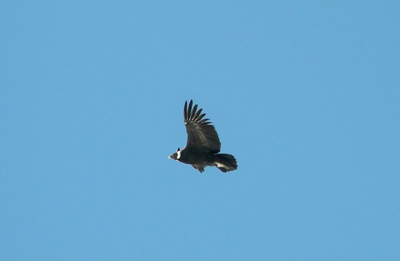 Andean Condor
After crossing the Horcones Inferior River on a wooden bridge, with steep slopes on either side, we got another view of the stagnant ice in the terminus us the Horcones Inferior Glacier. For most of the day the ascent was quite gradual along the floor of the glacial trough housing the Horcones Superior River. The first landmark was a huge rock (Piedra Grande o Colorado). Because of a strong wind in our faces all day, most of our stops were in the lee of a rock or bluff. Only where the river hugged the northeast side of the valley did we climb a few feet above the valley floor. The broadest part of the long valley has giant alluvial fans.
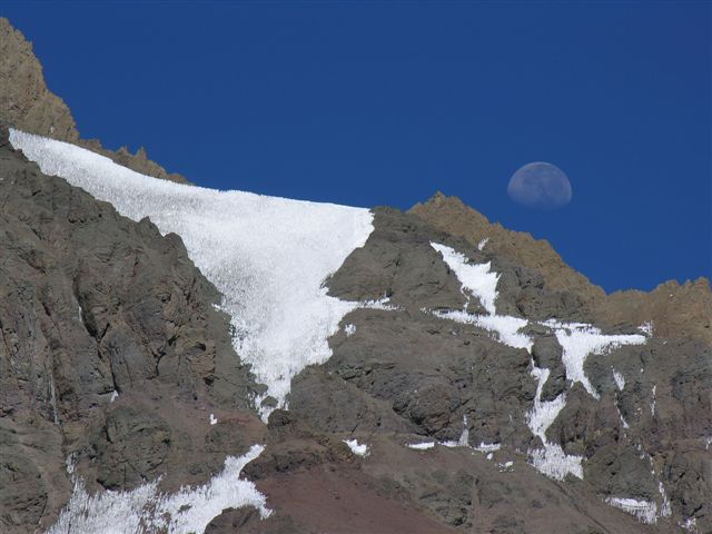
One by one spectacular peaks came into view, each a little more than 16,000 feet high; from south to north came Dedos, Bonete, Catedral, and Cuerno. The peaks are somewhat Matterhorn-shaped with varying cover of snow and ice. Quite spectacular is the west face of Aconcagua, not frequently climbed, but easier than the south face because it has little ice and snow and is not as steep.
Almost all the loose rocks along today’s route are andesite (porphyritic or breccia). We saw and then crossed our first neves penitentes on last winter’s avalanches. These snow towers generally exist only at high elevation and low latitude, and can be taller than a person.
 |
The biggest “wow!” of the day was a condor that flew very close to us because of a dead mule at the base of a very steep, long slope called Cuesta Brava. The condor soared back and forth below Ranger and me (who were higher), and at the level of some, and above others; many photos were taken. This slope exhausted some, with symptoms of headaches and nausea. By the top of the 1000-foot or so steep climb, Plaza de Mulas (elevation 14214 feet) was close.
Many, many tents of different sizes, shapes, and colors are here – room for hundreds of people, mostly men, and mostly attempting to summit Aconcagua. Generators, photovoltaic panels, wind turbines, and batteries provide energy for cooking, the internet, and satellite phones.
All around are neves penitentes, glaciers (including the huge Horcones Superior) and peaks. A few clouds dot the deep blue sky. I helped Juan and Natalia set up our one-, two-, and three- person tents before dinner. Mine is the closest to a small braided stream (beautiful music) and neves penitentes. As before we have a cook tent (with two cooks, reported to be the best here), a dining tent with windows all around, and an emergency tent in case of extremely high winds.
We talked after the soup, burgers, vegetables, and pineapple dessert. Sunlight lingered long on the west face of Aconcagua. [Edward James Carson was born this morning in Salt Lake City.]
Thursday: At 14,000 + feet, the stars are brilliant. Eventually the moon rose above Aconcagua’s west face, illuminating the nearby neves penitentes. Later the Milky Way appeared above Aconcagua, which had developed a lenticular cloud. After a very late breakfast we all went to the camp doctors for the same parameters as yesterday.
 |
Visible on the skyline are climbers thousands of feet above us on Aconcagua’s northwest ridge, the “normal route.” They are headed to Camp Canada at 16076 feet. This morning Juan ascended to there and back in two-three hours to say “hello” to friends; what phenomenal shape he is in!
After lunch Simon and I climbed up the moraines about 500 feet to a steep cone of rocks somehow left behind by the retreating Horcones Superior Glacier. We were gone 1.5 hours, spending some time watching climbers ascending the near part of Aconcagua above us.
We are reading, playing cards, talking, and napping today. I talked at length with artist Miguel who has an internet/satellite phone business (which I used to Call Salt Lake City). Our lasagna dinner was excellent, timed for the last sun on the top of Aconcagua, from which earlier clouds have disappeared. Juan briefed us on tomorrow’s climb of Cerro Bonete. The weather forecast is good.
The night was cloudless; the stars, including the constellation Orion, were brilliant. Again the moon rose above Aconcagua to illuminate not only the snowfields but also the peaks.
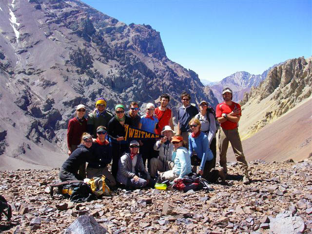
Friday: Cold turns quickly to warm when the sun rises in this high, dry air. Our climb of Cerro Bonete (elevation 16,430 feet) took nearly nine hours, including a pleasant hour on the summit. Juan and Natalia added a third guide Leo Rasnik. We started as two groups as far as the hotel across the valley; between here and there is the raging Horcones Superior River, which we crossed on a snow bridge of neves penitentes. Much of our route today was through fields of these tall snow towers. After the hotel much of the route is very steep, with loose rock. We switch backed up the talus (and glissaded down on our return). At about 15,000 feet two students were overcome with a combination of exhaustion, headaches, and blisters. Natalia took them down to the hotel (and then climbed solo to catch us at the summit). At another stream crossing (with a snow bridge of neves penitents) we reached an enormous bed or dike of gypsum. After that the andesite flows and breccias were replaced with conglomerate cut by green dikes.
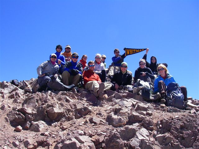 |
At a little above 16,000 feet we reached the summit pyramid. The diagonal traverse to the north was sketchy – loose rock and a lot of exposure. Gaining the ridge, we turned south and slowly scrambled to the summit. In all directions are 5000-m to 7000-m (16,000-foot to 23,000-foot) peaks; for great distances are jagged mountains, bumpy moraines, cliffs with snow patches, and brilliant glaciers. Above us a few small cumulus clouds punctuate the purple sky. We took hundreds of photos, many with the backdrop of Aconcagua towering across the valley. Juan pointed out two routes on the rarely climbed west face. He gave us two free satellite phone calls on the summit. Gretchen tried to call George Bridges and then Chuck Cleveland but could only get Donna Cummins on the third floor of Memorial Hall. I called Patti Moss; the students all yelled hello.
After a glorious hour of looking, eating, talking, and congratulating, we slowly and carefully descended the summit pyramid. Then we lost elevation quickly by talus glissading. After a while we split into three groups, the last being guide Leo, Laurel, Andrea, and me. Leo was interested in learning geology. We stopped briefly in the hotel (at about 14,000 feet elevation).
The only near accident of the trip happened when the last four of us tried to cross the Horcones Superior River. The narrow footbridge, one end on snow, looked (to me) less safe than the snow bridge with neves penitentes.
 |
Leo went across bothways to test them. As Laurel started across the snow bridge, it collapsed into small icebergs rushing down the muddy torrent. I grabbed Laurel, pulling her to the bank. Andrea was descending a ladder on the steep valley side; it shifted downward as part of the snow at its base fell into the river.As I joined the others to cross the wooden bridge, the steel ladder dropped another foot, and more of the snow bridge disintegrated. Safely on the other side, we watched as the river turned more of the snow bank into icebergs; the steel ladder dropped fast enough to make a splash in the river. Back at Plaza de Mulas we learned of the fifth death on Aconcagua this month (a sixth climber will die tomorrow). Soon after delicious snacks here at Plaza de Mulas, we were served a steak dinner topped off with cake and champagne. Bill of SpaceX visited our dinning tent to learn geology from me and tell us about future NASA and private space missions (he is here to attempt to climb Aconcagua).
I did not sleep well despite today’s exercise. Insomnia and apparent shortness of breath allowed me to stargaze through an open tent door for what seemed like hours. The brilliant stars were replaced with a moonlit Andean landscape. Ice formed on the nearby stream.
Saturday: Sunrise brought wave clouds over Aconcagua and other peaks. As the day progressed, dark clouds increased, with short sun breaks. It would have been a nasty day for an ascent, but it was almost ideal for a 15-mile hike because it was cool.
 |
After saying “goodbye” to the cooks we headed down the trail. The first obstacle was steep Cuesta Brava below Plaza de Mulas (I learned that in the past, mules took supplies to as high as about 20,000 feet on Aconcagua, doing the round trip from Plaza de Mulas in a day). After more moderate descent, the valley widened for a long trek to the canyon of Horcones Inferior River. We took a slightly different route than on our ascent, walking near the very muddy Horcones Superior River.
After crossing the canyon (steep down, a good foot bridge, and steep up), we reached Confluencia camp, where we rested only a few minutes. From the canyon almost to Horcones Ranger Station we had light rain showers, occasional hail, and variable winds. Patagonia and Aconcagua are the two windiest places I have ever been.
All day I thought about the geology of the area. What about the sandstones and conglomerates? Which are Mesozoic red beds, and which are distal fluvial facies of the Miocene volcanic complex? Of the white bands, the thin ones are 15-million-year-old trachytic dikes and sills; the thick ones seem to be Mesozoic gypsum mobilized into dikes, sills, and diapirs. The last snow bank is a giant avalanche deposit, is it at too low an elevation to have neves penitentes?
During the seven-hour descent we averaged almost two miles per hour, making three miles per hour on the last five miles. Our stamina overcame our blisters. The mood at Horcones Ranger Station was celebratory. Our bus took us to Hotel Ayelen at Los Penitentes, hot showers, and a banquet. Earlier I caught a glimpse of the summit of Cerro Bonete, white snow below, black clouds above.
Read about Cerro Torre and Glaciar Grande, Fitz Roy and Torres Del Paine
![]() To Bob Carson's Hompage
To Bob Carson's Hompage