click here for map
click here for profile
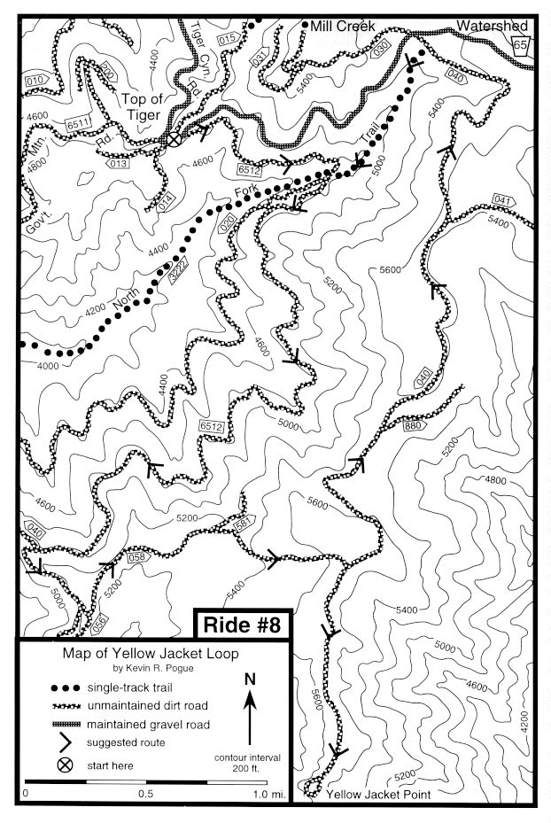
Starting point: Top of Tiger - See introduction for directions
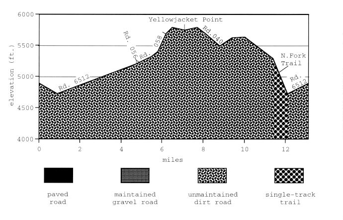
Ride Description: Begin the ride by gently descending 1.0 mile to the bottom of the upper North Fork Walla Walla River valley on USFS Road 6512. Stay on Road 6512 as it gently climbs out of the valley and then contours in and out of tributary valleys. Gated USFS Road 040 branches off on the right, 4.3 miles into the ride, after a long gentle climb. Bear left onto rocky USFS Road 056 as you near the ridge crest 0.4 mile further on. At the ridge crest, 300 ft. up Road 056, take a hard left onto Road 058. Stay on Road 058 by bearing right where Road 581 branches to the left near a clearcut 5.5 miles into the ride. Beginning 0.3 mile further on, the rutted dirt road climbs steeply to its intersection with the more well-traveled Road 040 6.2 miles into the ride. While steep, the climb is entirely rideable. Snowbanks may persist until late June on this section, requiring short portages. Turn right at Road 040 and ride 0.9 mile through open meadows on the ridgecrest to the tight loop that terminates Road 040 on the summit of Yellowjacket Point. On most days, the snowcapped peaks of the Wallowa and Elkhorn Mountains are visible to the southeast. On very clear days, Mt. Adams and Mt. Ranier are visible to the west. Turn around and ride 4.3 miles back past the Road 058 intersection and continue generally north on Road 040 bearing left at major intersections until you reach the trailhead for the North Fork Trail. Turn left onto the North Fork Trail and close the loop by swooping 0.6 mile down to Road 6512. If you miss the trail and intersect wide, graveled Road 65, look for the trail entrance 200 ft. behind you. Turn right onto Road 6512 and climb gently 1.0 mile back to the Top of Tiger.
Remarks: This is one of the best moderate routes in the area, especially for folks who are either intimidated by single-track or have yet to hone their technical skills. The views and the wildflowers are excellent.
Vital statistics:
Length: 13.1 miles
Total climbing: 1460 ft.
Time: 2-3 hours
Season: mid June to late October
Techno factor = 3; steep, rutted double-track climb
Grunt factor = 4; short steep climbs
Adventure factor = 2; mostly dirt roads
Some options:
1) If you really detest single track, you can avoid the North Fork Trail by riding the remaining 200 ft. to Road 65, turning left and riding 1.4 miles down to the Top of Tiger. T=2, G=4, A=1.
2) If this ride leaves you starved for technical single track, ride past the North Fork Trail to Road 65, ride 100 ft. downhill and link up with the Upper Indian Ridge Loop (see Ride #7) at ditched Road 030 on your right. T=8, G=5, A=6.
3) Ride the loop in the opposite direction. Begin by riding 1.4 miles up Road 65 and turning right onto Road 040. This version produces longer but gentler climbs and steeper and shorter descents with no single track. T=3, G=3, A=2.