click here for map
click here for profile
Starting Point: Bottom of Tiger Canyon Road - see introduction for directions.
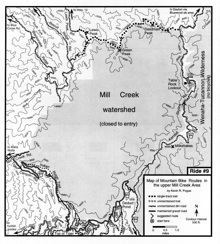
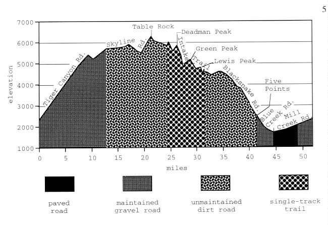
Ride Description: Ascend Tiger Canyon Road (USFS Road 65) to the intersection of Government Mountain Road (USFS 6511). This spot, where the Tiger Canyon Road crests the ridge separating the drainages of Tiger Creek and the North Fork Walla Walla River is referred to in this guidebook as the "Top of Tiger" and is a starting point for many mountain bike rides. From Mill Creek to the Top of Tiger, Tiger Canyon Road climbs 2450 ft. maintaining a fairly gentle grade over 7.5 miles. Stay on wide, graveled Road 65 and climb 1120 ft. in 5.3 miles to the intersection with the Kendall Skyline Road (USFS Road 64). Turn left onto the Skyline Road (rocky dirt) and ride 8.0 miles to the turnoff to the Table Rock lookout. This section contains 800 ft. of climbing, mostly in two moderate climbs, one near the Milkshakes peaks and the other just before Table Rock. Turn left and ride 0.5 mile up the rocky road to the lookout and spectacular views. Turn around and ride back down to the Skyline Road. Turn left on the Skyline Road and ride 2.5 miles along the ridgecrest to where the Intake Trail angles off to the left (west). The traihead is not signed; however, the trail is obvious if you are looking for it. The trail initially climbs steeply up to the ridgecrest (barely rideable, but very short) before contouring around the north side of Deadman Peak. After 6.4 miles of adventurous, technical single-track riding (and pushing) the main (well-worn) trail swings north toward the summit of Lewis Peak. Do not go to Lewis Peak and descend Lewis Peak Road or you will add many miles to this ride (and it's long enough already)! The actual Intake Trail continues straight where the more obvious Lewis Peak cuttoff branches off to the right. Follow the Intake Trail for 0.7 mile past the Lewis Peak cutoff to a fence on the right. Cross the fence and follow the dirt road on the other side to the left (west) for 0.5 mile to the junction with Biscuit Ridge Road. Turn left on Biscuit Ridge Road and ride 2.3 miles to Blacksnake Road. Turn right onto Blacksnake Road (rocky dirt) and descend 7.1 miles to the intersection with Blue Creek Road at Five Points (see Blue Creek-Dry Creek map). Turn left at Five Points and descend Blue Creek Road (graveled then paved) for 3.2 miles to the intersection with paved Mill Creek Road. Turn left on Mill Creek Road and climb gently for 7.4 miles on paved then graveled road back to the intersection of Tiger Canyon Road.
Remarks: Ridden in its entirety, this loop is a true test of athleticism and is only recommended for fit individuals in search of a challenge. Several of the options detailed below, however, are suitable for the weekend athlete. This ride traverses the highest peaks and ridges of the Blue Mountains near Walla Walla and affords spectacular views both to the east and west. The high elevation also restricts accessibility to this route as it is closed by snow for much of the year. The Intake Trail is remote, poorly maintained, and contains several unrideable climbs. Don't ride (and push) the Intake Trail unless you are the adventurous type.
Vital statistics:
Length: 51.9 miles
Total climbing: 6655 ft.
Time: a long day
Season: late June to mid October
Techno factor = 10; steep rocky downhills, unrideable uphills
Grunt factor = 10; short steep climbs, long grueling climbs, pushes
Adventure factor = 10; remote, injury potential high, difficult rescue, potential route-finding problems
Some options:
1) (shuttle required) Leave a car at the intersection of Blue Creek and Mill Creek Road and then drive up Tiger Canyon Road (USFS Road 65) past the Top of Tiger to the intersection with the Kendall Skyline Road (USFS Road 64). Start the ride here. Ride the remaining part of the loop to your car. This option eliminates the initial grueling climb and final gentle climb and thereby shortens the ride to 32 miles and drops the climbing to 2850 ft. T=10, G=7, A=8.
2) (shuttle required) Drive to the intersection of the Tiger Canyon Road (USFS Road 65) with the Kendall Skyline Road (USFS Road 64). Start the ride here. Ride the Skyline Road to the Table Rock Lookout. Return to the Skyline Road and then continue for 4.5 miles past the Intake Trail to an intersection where USFS Road 64 bears left and USFS Road 46 bears right and becomes the Kendall Skyline Road. Stay on wide graveled Road 64 which now descends for over 20 miles past Bluewood Ski area to Dayton. Have someone pick you up in Dayton. Although long in terms of mileage (32+ miles), this option contains only 1100 ft. of climbing, and no technical single-track. T=3, G=4, A=3.
3) Drive to the intersection of the Tiger Canyon Road (USFS Road 65) with the Kendall Skyline Road (USFS Road 64). Start the ride here. Ride the Skyline Road to the Table Rock Lookout. Turn around and ride back to your vehicle. The views are so spectacular along this portion of the route that you probably won't mind seeing them twice. This option is 17 miles long with 2100 ft. of climbing. T=3, G=4, A=2.