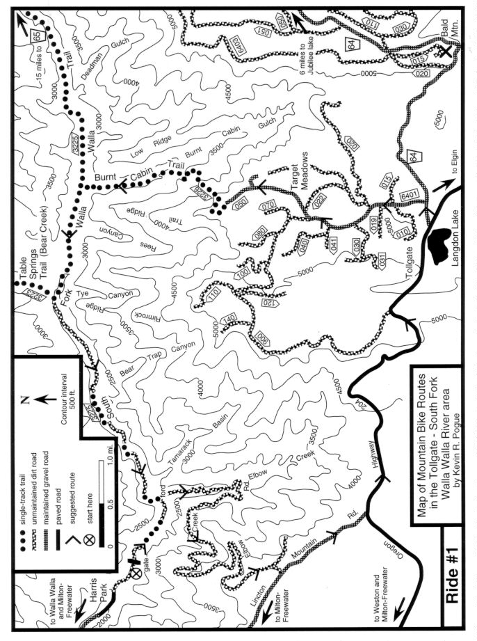
click here for map
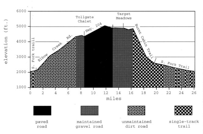
click here for profile
Starting point: BLM parking area - see introduction for directions.
Ride Description: From the BLM parking area ride around a gate and continue up the South Fork Walla Walla River on a dirt road. The South Fork Walla Walla River Trail branches off to the left 100 yards into the ride just before the road dead-ends at a former bridge. Follow the trail as it climbs along a steep hillside above the river. The trail regains the dirt road after 0.25 mile. Continue along the road until it dead-ends at another former bridge location (the trail continues up-river to the left at this point. Ford the river (this is cold and dangerous except at low water during late July - September) to reach Elbow Creek Road, ride around a gate, and continue gently climbing up the road. From the river to Lincton Mountain Road 6.3 miles further on, the Elbow Creek Road climbs 2173 ft. Ride around another gate 6.7 miles into the ride and continue climbing for another 0.5 mile. At the top of the ridge, bear right at a fork and continue 0.2 mile to the intersection with wide, graveled Lincton Mountain Road. Turn left and ride 1.3 miles on Lincton Mountain Road, climbing a gentle grade and then descending a short hill to the Tollgate Mountain Chalet (restaurant and snacks). At the Chalet, turn left onto paved and sometimes busy Oregon Highway 204. Stay on Hwy. 204 for 4.6 miles, climbing past the Haney viewpoint to the Tollgate store (snacks) and then descending past Langdon Lake. Near the lake, turn left onto graveled USFS road 64 at a sign to Jubilee Lake. After 0.3 mile, turn left again onto a graveled road (USFS 6401) marked by a sign to Target Meadows. After 1.5 miles, turn right toward the Target Meadows Campground. Bear left at a fork just past the campground and ride 0.6 mile until you reach a turnaround at the end of the road. The Burnt Cabin Trail begins at the northwest portion of the loop and is presently not marked. This single-track drops 2200 ft. in 3.3 miles to the South Fork Walla Walla River. The upper portion contains numerous challenging switchbacks and some rocky technical sections that will force most riders to either dismount for short stretches or at least dab a foot. The lower portion snakes through old growth forest with some interesting rocky creek crossings. A wooden footbridge spans the river just before you intersect the South Fork Walla Walla River Trail. Turn left onto this trail and descend the canyon for 5.1 miles where you complete the loop at the junction of the trail with the South Fork road. Turn right at the road and ride the remaining 1.0 downhill to the BLM parking area.
Remarks: Don't attempt the ford unless the water is low!! The removal of the bridge wher you must now ford the river was a very short-sighted action by the BLM. Call and help persuade them to put in a footbridge here. The ride is a classic. It may be the best loop ride in the area. Although long, the climb is the most pleasant of its size near Walla Walla. The road maintains a consistent gentle grade and the surface is generally smooth and compact. Since the Elbow Creek road is gated on both ends, you will not usually encounter any motorized vehicles and the views into the South Fork Canyon are spectacular. In the middle part of the ride there are two stores to replenish your food and water. The ride finishes with a 10 mile descent on single track and jeep trails.
Vital statistics:
Length: 26.1 miles
Total climbing: 3300 ft.
Time: 4-6 hours
Season: late July to October
Techno factor = 7; tight switchbacks, rocky single-track, creek crossings
Grunt factor = 6; 3300 ft. of climbing, but never very steep
Adventure factor = 7; injury possible on Burnt Cabin Trail, rescue difficult
Some Options:
1) Ride part way up Elbow Creek and turn around whenever you get tired. Then it's downhill back to the car. T=2, G=3, A=2
2) Follow the route description to Lincton Mountain Road. Instead of turning left toward Tollgate, turn right on Lincton Mountain Road. Bear right at the fork 5.8 miles later and after a short climb continue downhill for 4.2 miles to the intersection with the paved Walla Walla River Road. Turn right and follow the South Fork 9.2 miles upstream past Harris Park to the BLM parking area. T=2, G=5, A=2.
3) Follow the route description to USFS Road 64. Instead of turning left toward Target Meadows, continue on Road 64 toward and eventually past Jubilee Lake to the trailhead for the Rough Creek Trail (about 10 miles). Descend the Rough Creek Trail to the South Fork Walla Walla River Trail (4.5 miles). Descend the South Fork Trail to the South Fork road and the BLM parking area (12 miles). (See Top of Tiger overview map.) T=7, G=8, A=8.