click here for map
click here for profile
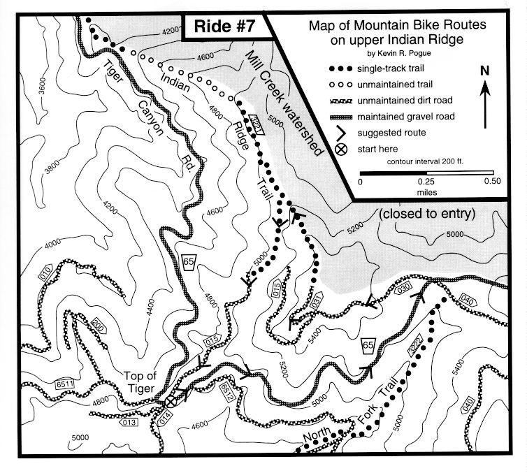
Starting point: Top of Tiger - See introduction for directions
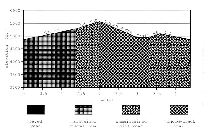
Ride Description: Ride up wide, graveled USFS Road 65 for 1.4 miles to just before USFS Road 040 intersects on the right. At this point, a large trench blocks access to USFS Road 030 on the left (north) side of Road 65. Carry your bike across the trench and ride up the road which climbs gently up and left (west). After following overgrown double-track trail across several earthen waterbars, bear right at a subtle fork in a rocky meadow. A short distance later, two miles into the ride, you will top out on a rocky ridge with excellent views to the northwest. At this point, very faint remnants of a very rocky road climb the ridgecrest to your right to the rocky summit of Indian Ridge. A cairn near the summit marks the beginning of the Indian Ridge Trail which follows the apex of the major ridge that trends to the north from the summit. The initial portion of the trail sidehills through a rocky meadow before it reaches the true crest of the ridge at a blocky cairn 300 ft. later. Follow the occasionally faint and very technical trail down the crest of the ridge for 1.0 mile until it intersects another single track that side-hills in from the left. Be on the lookout for this intersection unless you enjoy pushing or carrying your bike. Turn left at the intersection and ride 0.3 mile on this initially very technical side-hill trail to the junction with USFS Road 015. Follow Road 015 for 1.1 miles back to the Top of Tiger.
Remarks: Most of the people with the technical skills to enjoy this route will want more miles. This is easily accomplished by linking up with one of the Upper North Fork loops (see Ride #6). The Indian Ridge Trail is presently rideable for about 0.3 mile below the spur trail from Road 015. After this point, large sections of the trail have almost disappeared. Other rideable sections of the trail can be accessed from two-thirds of the way up Tiger Canyon Road but they presently also leave you stranded on the crest of the ridge when the trail disappears. If you enjoy the upper part of this trail, you are encouraged to lobby the Forest Service to rehabilitate the rest of the trail or volunteer to do it yourself. This trail has the potential to be one of the finest rides in the area.
Vital statistics:
Length: 4.5 miles
Total climbing: 780 ft.
Time: 0.75-1.5 hours
Season: mid June to late October
Techno factor = 7; narrow, steep, and rocky climbs, descents, and side-hills
Grunt factor = 3; short rocky climbs
Adventure factor = 6; some sections of route very faint, technical sections increase injury potential.
An option:
Where you intersect the trail that sidehills in from the left, stay right and continue riding (and occasionally pushing and carrying) down Indian Ridge for another mile until you can easily scramble down to Tiger Canyon Road. Ride 2.5 miles back uphill to the Top of Tiger. T=10 (if you try to ride most of it), G=4, A=8.