click here for map
click here for profile
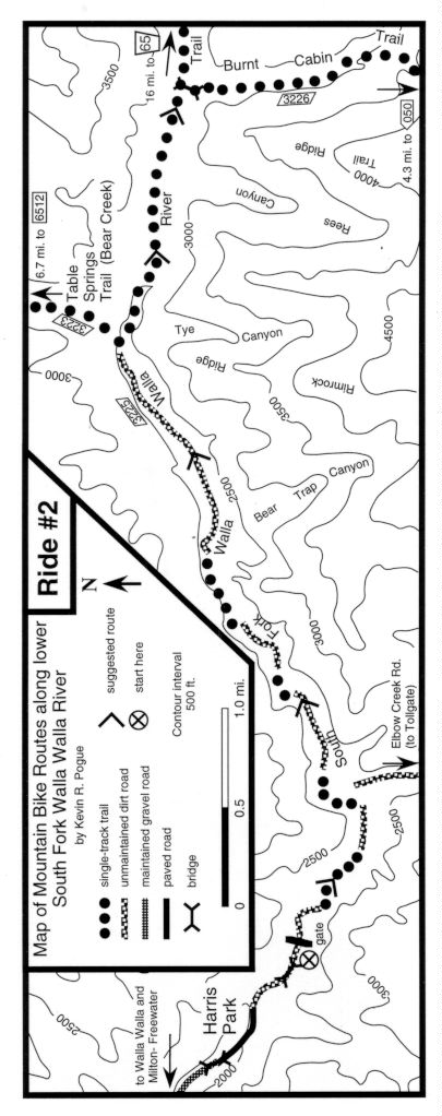
Starting point: BLM parking area - see introduction for directions.
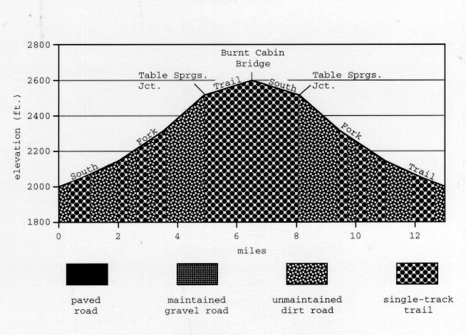
Ride Description: From the BLM parking area ride around a gate and continue up along the South Fork Walla Walla River on a dirt road. Turn left onto the South Fork Walla Walla River Trail 100 yards into the ride where the road dead-ends at a former bridge location. Follow the trail as it climbs along a steep hillside above the river. The trail regains the dirt road after 0.25 mile.One mile into the ride, just before the road dead-ends at another former bridge, turn left onto the South Fork Walla Walla River Trail. The lower portion of the South Fork Trail consists of short sections of single track that link together portions of a jeep trail. The jeep trail fords the river several times but the South Fork Trail always stays on the north side. Follow the trail upstream alternating between single- and double-track until you reach the turnoff for the Table Springs (Bear Creek) Trail about 5 miles into the ride. Continue straight ahead across a wooden footbridge. A mile and a half further on is the intersection with the Burnt Cabin Trail which crosses the South Fork on a large wooden footbridge. Although it is possible to continue up the South Fork Trail for many miles, this is the traditional turnaround point for most cyclists on this route. The return trip to Harris Park along the same route takes most cyclists much less time as it is gently downhill most of the way.
Remarks: This is by far the most heavily used trail in the area. You are guaranteed to encounter other bicyclists, motorcyclists, hikers, and horseback riders. User conflicts are inevitable and you are encouraged to ride under control and to be aware of other trail users. One of the purposes of this guidebook is to make local mountain cyclists aware that the lower South Fork Trail represents only one of many excellent routes in the area.
Vital statistics:
Length: 13 miles
Total climbing: 600 ft.
Time: 2-3 hours
Season: mid March to mid December
Techno factor = 4; rocky single-track, creek crossings
Grunt factor = 2; gentle gradients
Adventure factor = 2; short sections of narrow single-track adjacent to small cliffs
Some Options:
1) At the 5 mile point, just before the small footbridge, turn left onto the Table Springs Trail which climbs 1400 ft. in 2.3 miles to Cub (Bear Creek) Saddle, where there is wreckage of a small plane. Return by the same route. T=5, G=5, A=3.
2) Continue on up the South Fork Trail past the Burnt Cabin bridge for another 5 miles until you reach another wooden bridge where the Rough Creek (Reser) Trail crosses the river. Return by the same route. T=5, G=5, A=6 (big cliffs adjacent to trail, rescue difficult).
3) (shuttle required) Drive two cars to the BLM parking area. Leave one car there and drive the other one (with your bikes) to the Top of Tiger (1.3 hours). Drive 2.8 miles past the Top of Tiger parking lot and turn right onto USFS 894 or drive 0.3 mile further and turn right onto a new USFS road (see map #3). Both roads lead to Deduct Pond (parking, restrooms). Begin your 22 mile descent to the BLM parking area near a signboard at Deduct Pond. Bear left at a fork 0.3 mile later. The remainder of the ride is fairly straight-forward. The route is generally downhill but there are several relatively short steep and rocky ascents that will require some riders to dismount and push. This is a fantastic ride and is fairly popular even though you spend more time on the car seat than on the bike seat. T=6, G=5, A=7 (big drop-offs, rescue difficult).